



New Jersey’s atmosphere has become a study in meteorological extremes over the last several weeks, with the state swinging violently between record-setting cold and near-triple-digit heat in a pattern that has forecasters increasingly focused on the unstable upper-air configuration developing across North America. One week has delivered unusually chilly afternoons struggling to escape the 50s, while another has produced dangerous heat surging toward the upper-90s under oppressive humidity. The result has been one of the most erratic late-spring weather stretches New Jersey has experienced in years, a pattern now evolving again as forecasters track the development of a large-scale Omega Block expected to dominate conditions heading into the weekend.
The rapidly changing setup has created an atmosphere where New Jersey residents have struggled to establish any consistent seasonal rhythm. Air conditioning systems that sat idle during cool rain events were suddenly forced into full operation during the recent heat surge, only for cooler Canadian air masses to return days later. Meteorologists say those abrupt reversals are becoming increasingly tied to larger atmospheric disruptions taking shape across the Pacific and North America, including the strengthening influence of a developing Super El Niño pattern capable of amplifying temperature volatility and disrupting traditional jet stream behavior.
Despite the long-range uncertainty surrounding the evolving seasonal pattern, forecasters say confidence remains relatively high regarding the next seven days as a classic Omega Block configuration begins establishing itself across the continental United States. The setup, named after the Greek Omega symbol due to the shape it forces into the jet stream, is expected to play a major role in determining New Jersey’s immediate weather outlook.
Under the developing configuration, an upper-level low pressure system over the Northwestern United States will pair with another upper-level low over the Northeast while a pronounced ridge of high pressure strengthens across the central portion of the continent and extends northward into Canada. That arrangement forces the jet stream to arch dramatically northward before plunging back down into the eastern United States, producing the recognizable Omega-shaped atmospheric pattern that often leads to prolonged weather regimes and unusually stable conditions.
For New Jersey, the setup initially means one more significant push of heat and humidity before the pattern flips sharply cooler and considerably more comfortable by late week.
Temperatures already began climbing across much of the state Tuesday as warm, moisture-rich air expanded northward ahead of the approaching trough. Along the Interstate 95 corridor and New Jersey Turnpike region, temperatures climbed above 80 degrees while shore communities remained substantially cooler thanks to marine influence and persistent southeasterly flow coming off the Atlantic Ocean. Forecasters noted scattered showers lingering throughout portions of the state Tuesday evening as humidity levels continued rising overnight.
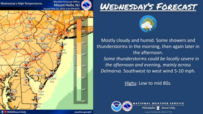
The atmosphere is expected to reach peak instability Wednesday as the warmest and most humid air of the week settles directly over New Jersey. Inland sections of the state are forecast to climb well into the 80s, with isolated areas potentially approaching 90 degrees away from the coastline. Coastal communities should remain somewhat moderated, with highs generally holding in the 70s due to ocean temperatures and persistent marine flow.
However, the growing heat and humidity are also expected to fuel widespread thunderstorm development Wednesday afternoon and evening as the advancing upper-level disturbance collides with the unstable air mass already in place. Meteorologists warn that some storms could become severe, particularly across interior portions of the state where atmospheric dynamics appear strongest.
The primary threats include damaging wind gusts, hail, intense lightning activity, and torrential downpours capable of briefly reducing visibility and creating localized flooding issues. Although New Jersey may avoid the most intense severe weather dynamics projected farther west, forecasters caution that isolated severe thunderstorms remain entirely possible statewide as the cold front moves through during peak daytime heating hours.
The timing of the storms may prove particularly disruptive given the ongoing increase in late-spring travel activity throughout the state. Commuters, outdoor workers, event organizers, and Jersey Shore businesses are all being advised to monitor conditions closely Wednesday afternoon and evening as rapidly developing thunderstorm cells could create dangerous travel conditions with little warning.
Once the storm line clears the region, however, the broader Omega Block pattern is expected to dramatically reshape the state’s weather heading into the latter half of the week.
Behind the departing front, noticeably cooler and significantly less humid air is forecast to spill southward into the Northeast, replacing the muggy summerlike atmosphere with what many residents may consider ideal late-spring conditions. Temperatures Thursday through Sunday are expected to settle primarily into the low-to-mid 70s during daytime hours, while overnight lows may dip into the upper 40s and low 50s across portions of North and Central Jersey.
Meteorologists stress that while those readings technically fall below seasonal averages for late May, the conditions are expected to feel exceptionally pleasant compared to the oppressive humidity and heat experienced earlier in the week. Sunshine levels are also forecast to increase substantially after Wednesday’s storms, with Thursday and Friday in particular expected to feature abundant sunshine, lower humidity, light northwest winds, and far more stable atmospheric conditions.
Thursday’s forecast currently calls for temperatures ranging through the 70s statewide with only isolated locations near the urban corridor briefly approaching 80 degrees. Winds shifting northwest behind the front will help usher in the drier air mass while skies gradually clear throughout the day. By Friday, conditions may become even more comfortable as widespread sunshine combines with highs in the upper 70s and relatively low humidity levels rarely seen during recent stretches of volatile spring weather.
The developing weekend outlook similarly points toward calm, seasonably mild conditions as the Omega Block continues anchoring cooler air over the Northeast. Forecast models currently indicate daytime highs remaining primarily in the low-to-mid 70s while nighttime temperatures fall into the upper 40s and lower 50s. More importantly for residents exhausted by the recent humidity swings, forecasters expect largely dry conditions and relatively stable skies through the weekend period.
Meteorologists caution, however, that the same blocking pattern responsible for the pleasant weekend conditions also reflects the broader atmospheric instability beginning to emerge globally under the strengthening El Niño influence. Blocking patterns can become stubborn and difficult to break down, occasionally locking regions into extended periods of unusual temperature departures, stalled storm tracks, or repetitive weather extremes.
The recent volatility already witnessed across New Jersey offers a preview of how unpredictable the broader warm-season pattern may become. Within just weeks, the state has experienced near-record cold afternoons struggling to climb beyond the upper 50s followed almost immediately by dangerous heat nearing 100 degrees in some interior locations. Those dramatic reversals are increasingly challenging traditional forecasting models and raising concerns about how the summer pattern itself may evolve as oceanic influences continue strengthening.
Still, forecasters believe New Jersey may finally begin stabilizing into a more seasonable regime by next week as the Omega Block gradually weakens and temperatures return closer to long-term late-spring averages. Early projections suggest highs could begin consistently climbing back into the upper 70s and low 80s by the end of next week, signaling a more sustainable warm-weather pattern after one of the most chaotic spring stretches in recent memory.
Until then, New Jersey residents are preparing for yet another abrupt atmospheric shift — one more reminder that the state’s 2026 weather pattern has become anything but predictable. In the span of only a few days, residents may once again move from severe thunderstorm alerts and oppressive humidity to crisp overnight lows, open-window weather, and bright sunshine under one of the most fascinating large-scale weather patterns currently shaping the American atmosphere.