


Winter Advisory in Effect as Sunday–Monday System Targets Much of the State
A winter weather advisory remains in place across New Jersey today, January 18, as an evolving coastal storm sets the stage for another round of plowable snowfall, particularly for North Jersey and inland sections of the state. Early Saturday snow has already produced measurable accumulation in northern areas, but attention now turns to a more organized Sunday into Monday system that carries a higher ceiling for impactful snow across a broader footprint.
This developing storm is the culmination of a favorable mid-January pattern that has been on the radar for several days. While an initial signal earlier in the week failed to materialize, the January 18–19 window is now aligning as expected. This is not a blockbuster blizzard scenario, but it is a legitimate coastal storm with the ability to produce meaningful snow totals and travel impacts for many New Jersey communities.
A key factor shaping this forecast is the behavior of an Arctic front that moved through the region more slowly than originally anticipated. That delay allowed Saturday’s disturbance to linger along the boundary, enhancing snowfall in areas already primed for accumulation. More importantly, the sluggish frontal progression means the boundary will remain closer to the coast as the next low-pressure system develops offshore. As a result, the coastal low is expected to track nearer to the Eastern Seaboard from Sunday into early Monday, allowing colder air and snow on the northwest side of the storm to push farther inland.
Forecast models have steadily adjusted toward this outcome. Early-morning guidance began trending colder and closer to the coast, and subsequent daytime runs have reinforced that shift. With additional model updates still to come, confidence continues to grow around a scenario that supports widespread snow rather than a narrowly confined event.
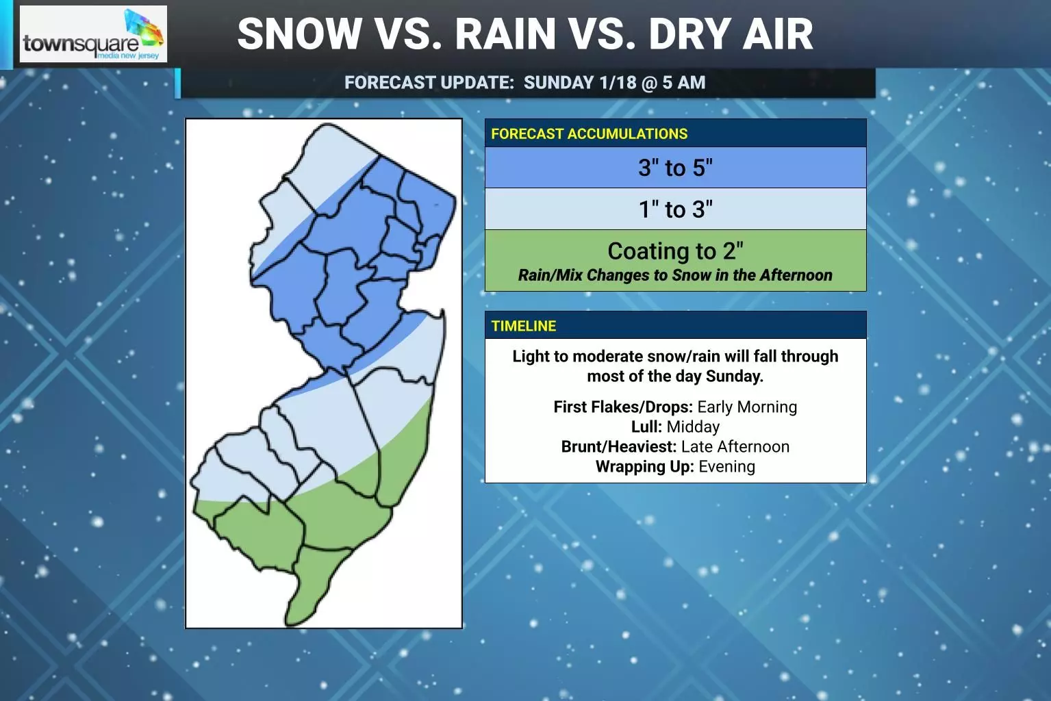
Coastal South and East-Central New Jersey remain the most challenging areas of the forecast. Surface temperatures in these zones are projected to hover in the low-to-mid 30s during the daytime hours on Sunday. However, heavier snowfall rates could dynamically cool the atmosphere, pulling colder air toward the surface and allowing snow to accumulate even near the coast. If precipitation begins earlier in the day, that cooling process becomes more effective. Conversely, the warmest part of the afternoon could briefly introduce mixed precipitation or rain at immediate shoreline locations before temperatures fall again Sunday evening, changing any mix back to snow. These uncertainties explain why coastal areas are being handled separately in the forecast outlook.
Timing has also expanded on both ends as the system’s potential has become clearer. Snow could begin as early as mid-morning Sunday, with lingering flakes possible into the early hours of Monday. The most impactful period is expected from midday Sunday through late Sunday night, when snowfall rates and coverage should be at their peak.
In plain terms, snow has already fallen this morning with accumulations confirmed in North Jersey, and another round is on the way that is likely to create plowable conditions across much of the state. Forecast snowfall projections remain intentionally conservative, reflecting a balanced expectation rather than an extreme outcome. Even so, this setup supports several inches of snow for many locations, with localized higher totals possible depending on banding and coastal temperature behavior.
Residents are encouraged to monitor updated forecasts and advisories as the storm approaches. Ongoing coverage and detailed updates are available through our dedicated [weather report] section, which will continue to track changes as this coastal system unfolds.

