TRENTON — New Jersey is emerging from a brief but intense cold snap into a milder, wetter pattern this week as Pacific air pushes eastward, setting the stage for what meteorologists are calling a “January thaw.” Tuesday, January 6, brings generally cloudy skies with highs reaching the low to mid-40s, about five degrees warmer than Monday. By late afternoon, spotty showers, drizzle, and fog are expected, particularly in northern regions of the state, where a Winter Weather Advisory goes into effect at 4:00 PM for elevated areas where rain may mix with snow or freezing rain.
Across the state, conditions are variable. Northern New Jersey faces the greatest risk of wintry precipitation on higher terrain, while southern counties and the Jersey Shore should see slightly warmer temperatures with rain as the primary form of precipitation. Light flurries and snow showers moved through parts of central and northern New Jersey on Monday, producing little to no accumulation, signaling the departure of the coldest air as the warming trend begins.
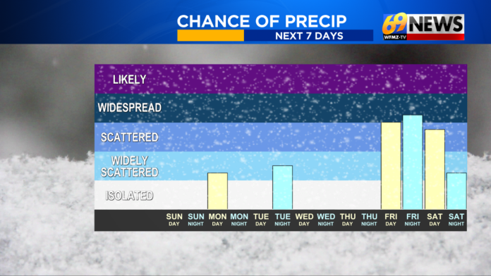
Trenton’s five-day outlook mirrors the statewide pattern. Tuesday’s high will reach around 44°F, with evening showers and fog lowering temperatures to near 29°F. Wednesday clears to mostly sunny and breezy skies with a high around 50°F and a low near 34°F. Thursday sees mostly sunny conditions with highs near 49°F, though clouds increase overnight as the region prepares for the next wet system. Friday and Saturday bring the warmest temperatures of the week, with highs reaching into the mid-50s and a chance of periods of rain, drizzle, and possibly heavier rainfall by Saturday, accompanied by a slight chance of a morning thunderstorm. A cold front arriving Saturday night is expected to restore winter-like conditions statewide on Sunday, marking the end of the thaw.
Meteorologists explain that this warm-up is largely the result of a complex atmospheric setup. Strong blocking over Greenland combined with a broad trough in the Eastern Pacific allows milder Pacific air to flow across the country from west to east. While this pattern brings temporary warmth and rain, it is expected to be short-lived within an otherwise prolonged cold season.
Global weather indicators such as the ENSO cycle show New Jersey transitioning from a weak La Niña to neutral conditions, with the potential for a weak El Niño by spring. Current signals, however, remain inconclusive for immediate impacts on winter precipitation, meaning that snow and cold events remain possible once the January thaw concludes. After the warm spell, meteorologists are closely monitoring signs for potential wintry storms around January 14 and between January 16–19, though confidence remains limited this far in advance.
Daily conditions through the week reflect this transitional period. On Tuesday, highs range from 42–48°F statewide with scattered rain for northern and central areas, possibly reaching elevated locations as a brief freezing rain threat early in the day. Wednesday sees mostly sunny skies with highs 45–52°F and breezy west winds, followed by Thursday with highs 45–55°F and periods of rain moving in from the west. Friday continues the warm and wet trend with highs 50–60°F and likely rain, while overnight lows remain mild in the upper 40s to near 50°F.
Residents should anticipate a weekend of milder, wet conditions before a colder air mass returns Sunday, potentially setting the stage for the next series of winter events. For ongoing updates, local advisories, and detailed forecasts, our weather section provides resources on how weather patterns may impact commerce, travel, and daily life throughout New Jersey.


