


New Jersey is bracing for a powerful and potentially historic winter event as a developing blizzard Nor’easter threatens to deliver heavy snowfall, damaging winds, coastal flooding, and widespread disruptions across the state. According to the latest forecasts and detailed weather analysis featured in Explore New Jersey Weather Report, the Garden State has officially entered what meteorologists describe as the “Kaboom Zone,” where conditions are expected to rapidly intensify between Sunday morning and Monday evening, February 22–23, 2026.
This long-form Sunset Daily News New Jersey feature provides an in-depth breakdown of the storm’s structure, timeline, regional impacts, and the three critical phases that will shape one of the most significant winter weather threats of the season. From the meteorological setup to statewide preparedness and projected snowfall totals, this comprehensive report delivers everything residents need to understand about the developing Nor’easter.
A Classic Nor’easter Forms: The Meteorological Setup Driving the Storm
The developing snowstorm is the result of a complex and highly dynamic atmospheric pattern unfolding across North America. A strong ridge forming across the western United States — positioned ideally along the Idaho and Montana axis — is forcing a deep storm trough across the eastern portion of the country. Multiple atmospheric disturbances, including polar and Pacific energy waves, are feeding into this trough, strengthening the system as it moves east.
As the storm evolves, the upper-level dynamics are expected to create a closed low-pressure system that will interact with a coastal surface low forming off the Outer Banks. This interaction will cause the storm to track close to the coastline before pulling away — a track historically associated with major Northeast snowstorms.
Meteorologists expect the system to undergo bombogenesis, a rapid intensification process that dramatically strengthens the storm’s pressure gradient. The result: powerful winds, intense snowfall rates, and severe coastal impacts, particularly along eastern and southern New Jersey.
The atmospheric configuration will also generate a broad precipitation shield covering New Jersey and surrounding states, with the potential for major to historic snow accumulations across large portions of the region.
New Jersey Enters the “Kaboom Zone”
Weather analysts warn that New Jersey is positioned directly within the most intense impact corridor of the storm. The Nor’easter’s track, moisture supply from the Atlantic Ocean, and rapidly strengthening pressure gradient create a scenario primed for heavy snowfall, blizzard conditions, and widespread disruption.
Expected impacts include:
• Heavy snow accumulation across most of the state
• Strong, gusty winds capable of causing power outages
• Hazardous travel and rapidly deteriorating road conditions
• Coastal flooding along eastern and southern shoreline communities
• Significant stress on infrastructure, utilities, and emergency services
For many communities, the storm represents a full-scale winter weather emergency scenario requiring careful preparation and caution.
Understanding the Storm: Three Critical Phases of Impact
Meteorologists have divided the event into three distinct 12-hour phases to help residents understand how conditions will evolve across the state.
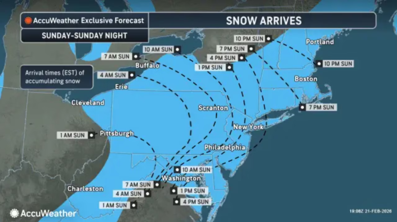
Snowstorm Phase I: Sunday 6 AM to Sunday 6 PM — The Transition Begins
The storm’s initial phase will feature variable conditions, particularly across central and southern New Jersey. Temperatures along the I-95 corridor and toward the southeastern coast may briefly climb into the upper 30s or low 40s, creating the possibility of rain at the onset.
During the morning hours, northern and northwestern New Jersey will begin with snowfall, while southern regions may initially experience rain or a rain-snow mix. A shifting precipitation boundary is expected to develop across the state between approximately 6 AM and early afternoon.
Forecast models differ on the extent of early rain, but any warmer conditions are expected to be temporary. Precipitation intensity will increase dramatically during the afternoon, triggering a rapid statewide transition to moderate snowfall.
By late afternoon or early evening:
• Northern New Jersey will shift from light to moderate snowfall
• Southern New Jersey will transition from rain to accumulating snow
• Road conditions will deteriorate rapidly
• Winds will begin strengthening, especially near coastal regions
By 6 PM Sunday, nearly the entire state — including Cape May — is expected to be experiencing steady snowfall, with early accumulations already underway in many regions.
Snowstorm Phase II: Sunday 6 PM to Monday 6 AM — Peak Storm Intensity
This phase represents the most dangerous and impactful portion of the storm. Meteorologists expect the system to intensify rapidly, producing heavy snow bands, falling temperatures, and strong winds.
Temperatures statewide are expected to drop into the mid-to-upper 20s, creating ideal conditions for sustained snowfall accumulation. The developing coastal low will pull cold air into the system, ensuring a fully frozen atmospheric profile that enhances snowflake growth.
Key characteristics of Phase II include:
• Intense snowfall rates and heavy accumulation
• Strong winds intensifying along coastal areas
• Potential thundersnow development
• Coastal flooding driven by persistent onshore winds
• Significant stress on trees and power lines from heavy snow weight
Snow during this phase will feature a dense, high-moisture consistency with snow ratios between 10:1 and 12:1, creating particularly heavy accumulation loads. This type of snow poses increased risks for downed tree limbs and utility disruptions.
Most of the storm’s total snowfall is expected during this overnight period as the Nor’easter reaches peak intensity.
Snowstorm Phase III: Monday 6 AM to Monday 6 PM — The Final Push
The final phase begins as winds shift to a northerly direction, signaling that the storm’s core is moving away from the region. While coastal impacts will begin to ease, cold air will dominate the atmosphere, producing lighter but more powdery snowfall.
This stage will feature:
• The coldest temperatures of the storm
• Fluffier snow with higher accumulation ratios
• Continued gusty winds statewide
• Final inches of snowfall before the system exits
Snow will gradually taper from west to east across New Jersey, with lingering flurries possible through Monday afternoon or early evening. By the time the storm concludes, residents across the state may face remarkable snowfall totals and widespread winter impacts.
Updated Snowfall Projections and Accumulation Zones
The latest snowfall projections indicate significant accumulations across most of New Jersey, with revised forecasts increasing potential totals in many areas. Northern and central regions are expected to receive the highest snowfall amounts, while parts of extreme southeastern New Jersey may see slightly lower totals due to early precipitation mixing.
However, forecasters caution that a faster transition from rain to snow could dramatically increase totals in southern coastal regions, potentially placing those areas within the storm’s highest accumulation zones.
Regardless of regional variations, the storm is expected to deliver substantial snowfall statewide, with impacts extending far beyond initial forecasts.
Coastal Flooding and Wind Threats
Beyond snowfall, the Nor’easter presents a serious coastal hazard. Strong onshore winds and a rapidly deepening low-pressure system will push ocean water toward the coastline, raising the risk of minor to moderate flooding in vulnerable areas.
Eastern and southern coastal communities face the greatest risk, particularly during the storm’s peak intensity Sunday night into Monday morning. Combined with strong wind gusts and heavy precipitation, shoreline communities may experience dangerous conditions and localized infrastructure impacts.
Statewide Preparedness and Public Safety Concerns
Officials across New Jersey are urging residents to prepare for extended winter conditions, avoid unnecessary travel, and monitor updates as the storm evolves. Emergency management teams are positioning equipment, preparing response crews, and coordinating with utility providers to address potential outages.
Transportation networks, municipal services, and public safety agencies are preparing for significant operational challenges as the storm unfolds. Residents are encouraged to secure supplies, prepare for possible power disruptions, and follow local emergency guidance.
A Defining Winter Event for New Jersey
The February 22–23 Nor’easter is shaping up to be one of the most consequential winter storms of the season for New Jersey. Its complex meteorological structure, extended duration, and multi-phase impact pattern create a high-impact scenario affecting transportation, infrastructure, coastal communities, and everyday life across the state.
From the initial transition of precipitation Sunday morning to the storm’s explosive overnight intensification and final departure Monday evening, the Garden State faces a full-spectrum winter weather event that could leave a lasting mark on the 2026 season.
As the storm approaches and conditions evolve, New Jersey stands at the center of a powerful atmospheric event — a classic Nor’easter poised to deliver heavy snow, powerful winds, and unforgettable winter conditions across the region.

