


Aurora Borealis Visibility Predicted Across Northern New Jersey as Solar Activity Peaks. Residents across Northern New Jersey have a rare celestial opportunity tonight as an intense solar storm is expected to produce visible auroras, more commonly known as the Northern Lights. Experts indicate that geomagnetic activity reaching high levels could allow the typically Arctic phenomenon to be seen at lower latitudes, creating a spectacular display for those who venture outdoors under clear skies.
The solar storm, triggered by a significant coronal mass ejection (CME) from the sun earlier this week, has heightened geomagnetic conditions, potentially lighting up the night sky with vibrant greens, purples, and reds. Auroras occur when charged particles from the sun collide with Earth’s magnetic field and atmosphere, producing luminous patterns that shift and shimmer unpredictably. While often associated with far northern regions, strong solar storms such as this can push the auroral oval further south, making it visible to observant skywatchers in New Jersey.
Meteorologists are advising residents in areas with limited light pollution—particularly in Sussex, Warren, and Morris counties—to keep an eye on the horizon after sunset. Conditions for viewing are optimal between 10 p.m. and 2 a.m., when the sky is darkest, though cloudy conditions in some regions may reduce visibility. For enthusiasts, the display offers both a scientific spectacle and a rare chance for stunning nighttime photography.
Local observatories and astronomy clubs have noted increased interest in tonight’s event, with many hosting guided viewing sessions and informational talks on auroras, solar storms, and the science behind geomagnetic activity. Experts stress that while auroras can appear suddenly and vary in intensity, tonight’s solar storm carries one of the higher probabilities for widespread visibility in the region this year.
Residents are encouraged to check local weather and aurora forecasts to identify the best viewing locations. Areas away from city lights, elevated vantage points, and open fields will offer the clearest perspectives. The combination of clear skies and strong geomagnetic activity could allow New Jerseyans to witness one of nature’s most awe-inspiring light shows, bringing a fleeting taste of the Arctic skies to the Garden State.
For more updates on tonight’s aurora and other weather phenomena across New Jersey, explore the Sunset Daily Weather Report. This rare astronomical event highlights the intersection of solar science and public fascination, offering both a stunning spectacle and a unique learning experience for the community.
Weekend Winter Storm Expected to Deliver Heavy Snow Across Northern and Central New Jersey. New Jersey residents should brace for a significant winter weather event this weekend as an Arctic snowstorm is set to sweep across much of the state, bringing potentially record-setting snow accumulations and gusty winds. Meteorologists are forecasting a high-impact snow event beginning early Sunday morning and continuing into Monday, with northern and central New Jersey expected to see the heaviest snowfall.
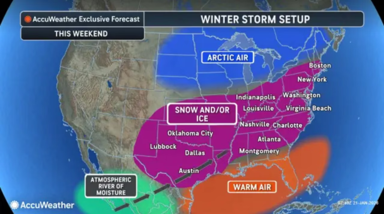
The storm is fueled by a powerful Arctic air mass currently moving south from the north-central United States, stretching over the Plains and advancing toward the Mid-Atlantic. This cold front will settle over New Jersey by Saturday, establishing a pronounced thermal gradient that will determine snow intensity across the state. Areas north of the gradient are expected to experience deep snow and sub-freezing temperatures, while regions to the south may see lighter accumulations with occasional sleet.
Upper-level dynamics are also playing a crucial role in shaping this storm. A Pacific-originating upper low near Baja California is phasing with a shortwave moving from western Canada, intensifying the storm system. The timing of this interaction is critical: a faster phasing could push the heaviest snow further north along the East Coast, while a slower progression may shift the snowfall axis slightly southward. This upper-level orchestration is why models have recently trended northward, predicting heavier totals across northern and central counties.
At the mid- and lower levels of the atmosphere, high-pressure systems within the Arctic air mass will guide the storm’s progression. Two primary highs—one over the northern Plains and another across southeastern Canada—are expected to steer cold air into New Jersey, reinforcing the Arctic temperatures. The position of the southeastern Canadian high in particular will influence whether warmer air intrudes into the storm’s precipitation shield, potentially creating brief periods of sleet in southern New Jersey while leaving the north predominantly snow-covered.
Current model guidance anticipates a snow-to-liquid ratio between 15:1 and 20:1, highlighting the light, fluffy nature of the expected snow. Some southern areas may experience ratios closer to 10:1 if sleet mixing occurs. With the Arctic air mass so robust, meteorologists emphasize that even a comparatively weak low will struggle to diminish snowfall totals significantly. Observers should expect snow accumulation anywhere from 8 to 16 inches in northern and central counties, with a possibility of localized amounts exceeding 18 inches depending on wind drift and banding effects.
Meteorological teams have incorporated recent data from hurricane-hunter missions into their forecasts, which has shifted guidance slightly northward, confirming widespread snow coverage across most of New Jersey. While southern areas could see a short-lived sleet mix along the I-95 corridor, the primary narrative for this weekend is heavy, accumulating snow that may disrupt travel and daily activities.
Authorities and weather enthusiasts alike are monitoring the situation closely. Forecast teams plan to release updated snow maps Friday, with live observations commencing Sunday morning. Residents are advised to prepare early, ensure access to essential supplies, and plan for potential school and business closures. This weekend’s storm represents one of the most significant winter events of the season, bringing the full force of Arctic conditions to the Garden State.
For continuous updates and detailed regional forecasts, check the Sunset Daily Weather Report. This upcoming snowstorm underscores the importance of staying informed and ready as New Jersey faces a rare and intense winter system.

