


New Jersey is experiencing a dramatic winter chill as the coldest day of 2026 so far grips the state. An arctic blast has arrived, bringing dangerously low wind chills, powerful gusts, and conditions that residents are being urged to treat with caution. This week’s forecast highlights the challenges ahead, from frigid highs barely reaching the twenties to a looming winter storm expected to blanket parts of the state in significant snow.
Tuesday, January 20, is a stark reminder of the power of winter. While skies are mostly bright and sunny, temperatures are struggling to rise above 22°F to 26°F across most of New Jersey. Strong winds—gusting up to 30 mph—push “feels-like” temperatures into the single digits, with some inland areas experiencing wind chills as low as -15°F early this morning. Residents are advised to bundle up, limit time outdoors, and ensure pets and vulnerable neighbors are protected from the cold. Overnight, skies will remain clear, with lows dropping to 10°F to 13°F, continuing the deep freeze through early Wednesday morning.
Wednesday, January 21, offers a modest reprieve as temperatures rebound slightly. Highs are expected to climb to the mid-30s, ranging from 34°F to 38°F. While still cold, the less harsh wind and slightly warmer air may allow for brief outdoor activities. Thursday, January 22, is shaping up as the mildest day of the week. Temperatures could reach the upper 40s in some southern areas, offering a brief break before another arctic front returns. By Friday, January 23, the cold returns, with highs dropping back into the 30s, setting the stage for a prolonged winter freeze over the weekend.
Adding to the winter challenges, forecasters are closely monitoring a significant snowstorm projected to impact New Jersey between Saturday night, January 24, and Sunday night, January 26. Current models show high confidence for at least 5 inches of snow across Southern New Jersey and the Jersey Shore, though totals may vary as the storm evolves. Due to the extreme cold, the snow is expected to be dry and powdery, which could result in rapid accumulations and create hazardous travel conditions.
Several counties, including Burlington, have already issued Code Blue alerts, opening warming centers to protect residents from the dangerous cold. Authorities are urging citizens to stay updated on local conditions and take precautions, especially during nighttime hours when the combination of frigid temperatures and lingering snow can create icy surfaces and travel hazards.
For those following the storm and regional conditions, real-time radar, snowfall updates, and emergency notifications are available through the National Weather Service in Mount Holly. With New Jersey entering one of its most intense cold snaps of the season, residents are reminded to plan ahead, monitor updates, and prioritize safety for themselves and their communities.
This week serves as a stark reminder of the state’s winter volatility, combining biting cold, fluctuating temperatures, and an impending snowstorm that could disrupt travel and daily life. By staying informed and prepared, New Jerseyans can navigate these extreme conditions safely while keeping homes, families, and pets protected.
New Jersey Faces Historic Cold and Weekend Snowstorm Potential: Expert Analysis and Weather Outlook. New Jersey is bracing for an extended Arctic cold pattern this week, with meteorologists and weather experts warning of dangerously low temperatures and the possibility of a major snowstorm this weekend. The state is already experiencing a sharp taste of the cold, and residents are being urged to prepare for a prolonged freeze and potential disruptions in travel, utilities, and daily life.
Safety remains the top priority as this winter pattern unfolds. Residents should take proactive measures to protect themselves, their families, and their property. This includes ensuring adequate heating, stockpiling essential food and supplies, protecting plumbing from freezing, and preparing for the possibility of being snowed in through the weekend and into early next week. While the snowstorm forecast carries slightly lower confidence than the confirmed cold, if it materializes, it could rank among the most impactful storms New Jersey has seen in recent years.
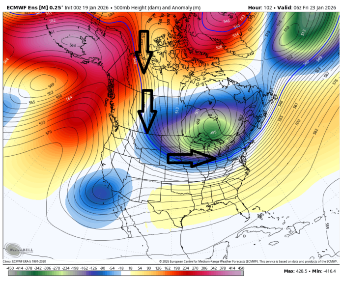
The long-range pattern indicates a significant shift into Arctic air beginning Friday night. Tuesday offers a brief preview, with high pressure bringing transient cold that will produce highs in the 20s across much of the state and lows in the teens or single digits in elevated areas. From Wednesday through Thursday, temperatures moderate slightly, with highs climbing into the 30s and 40s, providing a short break before the main Arctic front pushes through Friday night into Saturday. This cold will not be brief—forecasters expect well-below-average temperatures to persist through late January and into February, with transient warm-ups punctuating a dominant cold pattern reminiscent of the historic winters of 2013–2014 and January 2018.
Multiple global and regional climate indicators are converging to create this extreme cold pattern. The transition from a La Niña to a neutral ENSO phase this February, combined with a positive Pacific North American pattern and a negative Arctic Oscillation, is creating a direct channel for frigid Arctic air to flow south into New Jersey. Cross-polar flow from Siberia to the eastern United States will reinforce this cold, while a -NAO pattern over Greenland slows storm systems, allowing the Arctic air to remain entrenched. These teleconnections, along with the Madden-Julian Oscillation now moving toward Phase 8, create conditions favorable for both prolonged cold and significant winter precipitation.
While the extended cold is confirmed, the potential snowstorm this weekend remains under close observation. Current ensemble models indicate a window of opportunity from Saturday, January 24, through Sunday night, January 26. Key atmospheric ingredients are in place: a deep Arctic air mass from the north, a thermal gradient running from the southern U.S. into the Mid-Atlantic, and moisture tapped from the subtropical jet stream. While the storm is not expected to produce blizzard-force winds, dry Arctic air combined with the incoming moisture could yield rapid, heavy snowfall, particularly in Southern New Jersey and along the Jersey Shore. Snow-to-liquid ratios may exceed 15:1, potentially doubling initial accumulation forecasts, with impacts depending heavily on the position and strength of an Arctic high over the Midwest.
This week’s programming for weather updates has been structured to provide residents with the most timely and actionable information. From Monday through Wednesday, analysis of model convergence will guide probabilistic expectations for snow and regional impacts. By Wednesday, a preliminary “Storm Go vs. No-Go” decision will be shared, refined on Thursday with the first snow maps and forecasts. Updates will continue Friday with adjustments based on final model consensus, followed by live observation videos beginning Saturday afternoon and continuing into Monday morning to capture the event in real time. Subscribers to the KABOOM Club will receive ad-free updates, priority responses to questions, and detailed model analysis daily.
In practical terms, Tuesday will offer residents a preview of the cold, with highs only reaching 20–30°F and overnight lows dipping into the teens. Wednesday and Thursday will be milder, with highs in the 30s and 40s, before the main Arctic front drops into New Jersey Friday night. Saturday through Monday may bring the most significant snow event of the season if the storm materializes. While exact amounts remain uncertain, snow accumulations could be substantial, with the potential to disrupt travel, school schedules, and community activities.
This week’s weather represents a high-stakes scenario, combining historic cold with the possibility of a major snowstorm. Residents are encouraged to prepare early, monitor updates closely, and take the necessary precautions to remain safe during this extreme pattern. With careful planning, New Jerseyans can weather the cold, navigate potential snowfall, and stay informed through timely, expert-led reporting from Sunset Daily News.

