


Forecasters warn of high-impact winter weather as models converge but critical details remain in flux
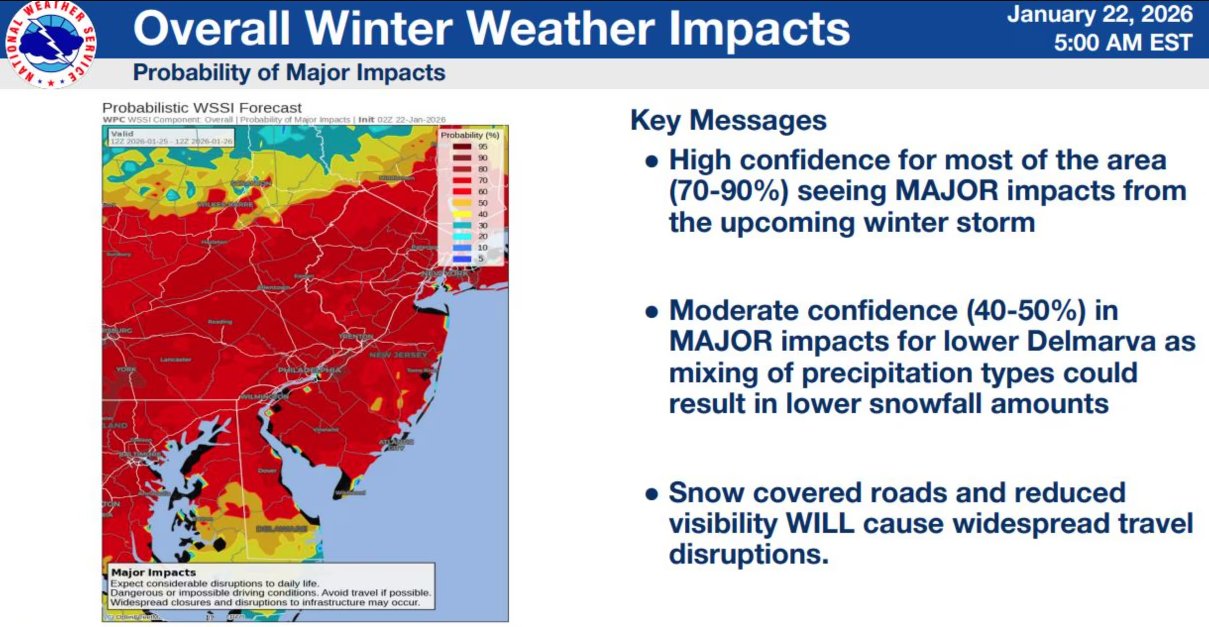
New Jersey is bracing for a high-impact winter storm as Arctic air locks into place and a developing coastal system targets the region late this weekend into early next week. While the event is still more than a day away, confidence is growing that a significant snowstorm will affect much of the state between early Sunday morning and midday Monday, bringing hazardous travel, bitter cold, and the potential for substantial accumulations.
Meteorologists caution that while the overall threat is solidifying, fine details remain unresolved and could dramatically alter outcomes. History shows that even within a 36-hour window, small atmospheric shifts can mean the difference between a blockbuster snowstorm and a messy mix of precipitation. That uncertainty is now centered on two main concerns: the intrusion of warmer air aloft and the possibility of a complex coastal storm evolution.
One key issue is warm air advection, a process that allows milder ocean air to surge into the mid-levels of the atmosphere even while surface temperatures remain below freezing. When this happens, snowflakes can partially or fully melt before refreezing as sleet or freezing rain, cutting down on snow totals while increasing ice impacts. This scenario is most concerning for central and southern portions of the state, particularly along and southeast of the Interstate 95 corridor.
Another closely watched factor is the potential for a so-called Miller-B storm evolution. In this setup, an initial inland low-pressure system weakens as a new coastal low rapidly forms offshore. This transition can temporarily shut down precipitation in a “dry slot” before intense snow redevelops on the northwest side of the newly formed storm. While current guidance suggests the heaviest effects of this transfer may stay west of New Jersey, even a slight eastward shift could significantly impact snowfall distribution across the state.
What forecasters are increasingly confident about is that this storm will not miss to the south. The high-pressure system over southeastern Canada, which earlier threatened to suppress the storm, has weakened just enough to allow the system to track farther north. As a result, if the storm underperforms, it would likely be due to excessive warming rather than lack of precipitation. That raises the stakes for areas caught near the rain-snow line, where totals could swing wildly over short distances.
Northern New Jersey, particularly areas north of Interstate 78, appears best positioned to remain locked in all snow for the duration of the event. These regions are expected to stay well below freezing, allowing snow to accumulate efficiently with high snow-to-liquid ratios. Central New Jersey, especially between Interstate 195 and I-78, sits in the zone of greatest uncertainty, where prolonged snow could abruptly change to sleet. Farther south and east, the risk of mixing with rain increases, though even these areas are expected to see a meaningful period of accumulating snow before any changeover.
Model guidance continues to evolve, but recent trends have favored solutions that deliver significant snowfall to large portions of the state. One leading model has shown notable consistency, depicting a single dominant coastal low that tracks near the classic benchmark offshore. In this scenario, warmer air struggles to penetrate inland, keeping most of New Jersey in snow or snow mixed with sleet rather than rain. Other models introduce a faster retreat of cold air, allowing a warm layer to push farther inland and increase the risk of ice or rain, particularly in southern and central counties.
Regardless of precipitation type, temperatures will remain firmly in Arctic territory. Even areas that briefly mix may stay in the teens or 20s, meaning any precipitation that falls will freeze efficiently on contact. Where snow dominates, fluffy, high-ratio snowfall is expected, allowing accumulations to pile up quickly. Sharp gradients are likely, with dramatic differences in totals over relatively short distances.
Based on current data, forecasters are emphasizing probability-based expectations rather than fixed totals. Northern sections have the highest likelihood of exceeding a foot of snow, with some locations potentially reaching well beyond that if snow remains uninterrupted. Central areas are expected to see double-digit snow totals as a baseline before any mixing, while southern regions still appear likely to reach advisory- or warning-level snow amounts before transitioning to sleet or rain and then back to snow as colder air surges in behind the departing storm.
The storm is expected to unfold in three main phases. Snow should overspread the state late Saturday night, becoming widespread toward midnight as dry Arctic air saturates. Sunday morning through the evening will be the most volatile period, when warmer air attempts to intrude from the ocean, especially in southern and coastal areas. By Sunday night into Monday morning, colder air is expected to rush back in, flipping any mixed precipitation back to snow before the system finally pulls away.
Residents are urged to monitor updates closely as the forecast sharpens. Even small track changes could have outsized impacts on travel, power infrastructure, and daily life. With Arctic cold in place and a powerful storm system approaching, New Jersey appears headed for a consequential winter weather event that will dominate the regional weather report and demand serious preparation.

