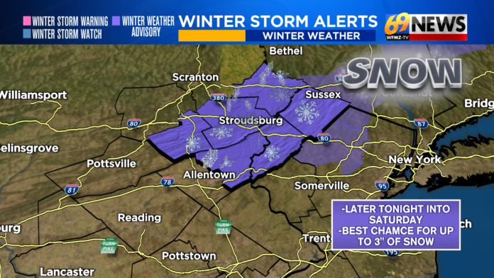
New Jersey is bracing for a wintry stretch as a pair of weather systems set the stage for snow, sharply colder temperatures, and biting wind chills that will linger into early next week. While neither system appears poised to deliver a blockbuster storm on its own, the combined setup has raised concerns for slippery travel, localized accumulations, and an extended blast of Arctic cold across the state.
Forecasters now have greater confidence in how the weekend is likely to unfold after weather models began aligning on a similar scenario. The first system arrives late Friday night as an Arctic cold front presses through the Mid-Atlantic. As that front moves across Pennsylvania and New Jersey, it will be accompanied by a subtle disturbance in the upper atmosphere, providing just enough lift to generate snow showers in parts of the state.
The most favorable window for snow from this initial round runs from around midnight through mid-morning Saturday. Northern New Jersey, particularly communities north of Interstate 78, stands the best chance of seeing accumulating snow during this period. Some flurries or light snow showers could develop earlier Friday evening, but the more organized activity is expected overnight. By late Saturday morning or around midday, snow should taper off completely, giving way to a brief break in precipitation. That lull will come with a reinforcing surge of cold air, setting the stage for a frigid Saturday night.
Attention then turns to Sunday, when a separate but related system may come into play. As the cold front settles offshore, a weak coastal low is expected to develop well off the Outer Banks and track northeastward. If it follows the current projected path, snow could spread into southern and southeastern New Jersey from late morning through Sunday evening. Areas along and southeast of the Interstate 95 and New Jersey Turnpike corridor would be the most likely to see steady snowfall during this time frame.
The tricky part of this forecast lies in how the two systems interact. The strength and impact of Saturday morning’s snow in northern New Jersey will directly influence where the offshore boundary ends up, which in turn determines how close Sunday’s coastal system comes to the state. A stronger Arctic push on Saturday would shove that boundary farther out to sea, increasing the odds that Sunday’s system stays offshore and delivers only minimal snow, if any, to southern New Jersey. A weaker first round, however, would allow the boundary to linger closer to the coast, giving Sunday’s system a better chance to bring measurable snow farther inland.
Because of this uncertainty, snowfall totals remain highly dependent on location and timing. While neither system is expected to produce widespread heavy snow, either could generate a plowable accumulation in localized areas. An upper-end scenario could approach several inches in the hardest-hit spots, though many communities will see less. There is also a zone between Interstate 78 and the I-95/New Jersey Turnpike corridor that may end up on the losing end of both systems, with little more than nuisance snow or flurries.
In plain terms, residents should be prepared for two separate snow windows: late Friday night into Saturday morning, mainly favoring northern New Jersey, and late Sunday morning through Sunday evening, mainly favoring the southern and coastal portions of the state. How much snow falls on Sunday will depend heavily on what happens overnight Friday into Saturday.
Behind the snow, the bigger story may be the cold. Arctic air will surge in after the systems pass, sending temperatures plunging and wind chills dropping well below zero in some areas through Tuesday. This prolonged cold snap could create hazardous conditions beyond snowfall, including icy roads, frozen pipes, and dangerous exposure risks.
Residents are urged to stay informed as the forecast continues to evolve. Ongoing updates and detailed outlooks are available through Sunset Daily’s weather coverage, including the latest insights in our ongoing weather report section. As always with winter weather in New Jersey, small shifts in timing and track can make a big difference, and the weekend ahead will be one to watch closely.


