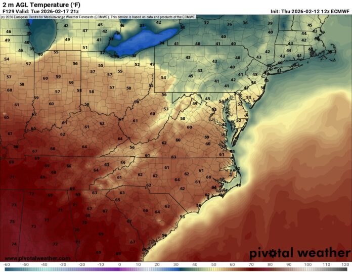
After weeks of punishing cold that pushed much of New Jersey into survival mode, the Garden State is finally preparing for a meaningful turnaround in temperatures this Valentine’s Day weekend — a welcome shift following a stretch of weather that has already been linked to at least 20 cold- and weather-related deaths statewide between late January and early February.
Many of the victims were discovered in unheated or inadequately heated environments, underscoring how severe and sustained this winter pattern has been across urban, suburban, and rural communities alike. Emergency responders and social service agencies have described the period as one of the most dangerous cold spells in recent memory, particularly for older residents, people experiencing housing insecurity, and those living in homes with unreliable heat.
The first ten days of February alone averaged just 16.6 degrees statewide — nearly 13 degrees below seasonal norms — locking New Jersey into a deep freeze that stalled outdoor activity, strained local infrastructure, and intensified public health concerns. Road crews battled repeated refreezing, municipal public works departments faced frozen pipes and water-main issues, and schools and local governments scrambled to manage heating challenges during the prolonged cold snap.
Now, forecasters say a long-awaited “February thaw” is finally arriving — and for many residents, the timing could not be better.
Saturday, which also falls on Valentine’s Day, is shaping up to be the most pleasant day of the entire week across New Jersey. Skies are expected to be mostly sunny statewide, with afternoon temperatures climbing into the mid-to-upper 40s. In parts of South Jersey, thermometers could briefly touch the 50-degree mark, offering a rare midwinter opportunity for outdoor plans, small business foot traffic, and community events that were repeatedly postponed during the bitter cold.
The return of calmer conditions will be especially noticeable after days of strong northwest winds that frequently gusted between 25 and 35 miles per hour earlier this week. Those winds are forecast to fade by Friday night, setting the stage for a much quieter and more comfortable Saturday throughout North, Central, and South Jersey.
The improved weather will also accelerate snowmelt from the lingering snowpack left behind by late January storms. With sunshine dominating both Friday and Saturday, residents can expect visible clearing of sidewalks, driveways, and secondary roadways. However, officials are urging drivers and pedestrians to remain cautious, as melting during the daytime followed by overnight refreezing could still create slick conditions in shaded areas and on untreated surfaces.
Sunday, however, brings a less predictable and increasingly unsettled weather pattern.
Cloud cover is expected to thicken through the morning, and forecasters are tracking a coastal storm system that could begin influencing the state late in the afternoon and evening hours. Current projections suggest a 30 to 51 percent chance of precipitation developing toward the end of the day, with rain or snow showers possible depending on location and timing. High temperatures will remain in the low-to-mid 40s, keeping much of the state right on the edge of rain versus snow as the system moves closer.
Looking beyond Sunday, meteorologists are paying close attention to a developing storm that could affect New Jersey Sunday night into Monday. While the exact track remains uncertain, the current outlook leans toward rain for much of South Jersey, while northern counties may experience a mix of rain and snow if colder air lingers longer. Small shifts in the storm’s path could still change precipitation types, particularly in higher elevations and interior northern communities.
For emergency management officials, the transition from extreme cold to fluctuating temperatures introduces a new set of concerns. Rapid snowmelt combined with incoming rainfall could lead to localized ponding of water, clogged storm drains, and minor flooding in low-lying and poor-drainage areas. Residents are encouraged to clear nearby storm grates and remain alert for changing road conditions as the thaw unfolds.
State and local agencies are also continuing to stress cold-weather safety, reminding residents that despite the upcoming warmup, winter hazards remain very real. Heating systems, carbon monoxide detectors, and access to warm shelter continue to be top priorities as temperatures fluctuate.
New Jersey residents can continue to follow evolving conditions, storm timing updates, and localized forecasts by checking the latest statewide weather report coverage throughout the weekend and into early next week.
While this weekend’s thaw will not erase the toll of one of the harshest stretches of winter weather in recent years, it does provide a critical break — offering safer travel, renewed outdoor activity, and a brief sense of seasonal normalcy after weeks defined by dangerous cold, high winds, and mounting public safety concerns across the Garden State.


