After one of the harshest cold stretches of the season, New Jersey is finally stepping away from the kind of arctic air that kept daytime highs in the teens and sent overnight temperatures well below zero just days ago. While the coming week will feel dramatically calmer by comparison, meteorologists caution that winter is far from finished and that the state is now entering what is historically the snowiest portion of the season.
Forecasters across the region are gaining increasing confidence that the extreme cold experienced in late January and the opening days of February marked the true bottom of the winter temperature curve. In practical terms, the odds of seeing another prolonged outbreak of single-digit highs and sub-zero lows before spring are steadily diminishing. That does not mean a warm pattern is taking over, but it does suggest that New Jersey has moved beyond the most severe cold of the 2025–2026 winter cycle.
For the remainder of this week and into early next week, temperatures across the state are expected to hover near or slightly below normal. Typical mid-February afternoon highs in New Jersey range from about 40 to 45 degrees from North Jersey through South Jersey. Forecast highs in the upper 30s may feel almost springlike after the recent deep freeze, but climatologically they still fall on the cool side of average.
The only notable interruption to this cooler-than-normal trend is expected during a brief window between February 17 and February 19, when a transient shift in the upper-air pattern could allow temperatures to edge slightly above seasonal norms before cooler air returns. That warmer pocket is not expected to linger.
Residents looking ahead to travel plans and outdoor activities can follow the latest updates and local outlooks through Sunset Daily’s ongoing New Jersey weather coverage in our embedded weather report section, which tracks daily changes and developing storm signals statewide.
While afternoons will increasingly climb above freezing in the days ahead, overnight lows are still forecast to dip below 32 degrees on many nights. That combination is particularly important for snowfall potential. With Presidents Day weekend approaching, the rising sun angle will begin to play a larger role in how efficiently snow can accumulate during daylight hours. After mid-February, snow that falls during the afternoon must be heavier and more persistent to overcome daytime melting, while overnight and early-morning precipitation can still accumulate more easily on colder surfaces.
As the calendar moves closer to March, this effect becomes even more pronounced each year. Snowstorms remain very much possible, but the timing of precipitation increasingly determines whether accumulations stick.
Larger-scale climate signals continue to support a pattern that favors colder air remaining anchored over the northern Mid-Atlantic and Northeast. The evolving interaction between Pacific and tropical influences is expected to keep the subtropical jet stream more active, meaning more opportunities for moisture to move into the region. At the same time, New Jersey is projected to remain on the colder side of that jet, increasing the likelihood that future storm systems arrive with at least some wintry component, particularly overnight.
This type of setup often produces what forecasters describe as an “overrunning” pattern, in which warmer, moisture-laden air rides over colder air near the surface. In New Jersey, that configuration can lead to snow, sleet or mixed precipitation events while much of the southern United States experiences rain and mild temperatures. It is a common late-winter pattern for the northern Mid-Atlantic and one that historically produces several of the season’s most impactful snow events.
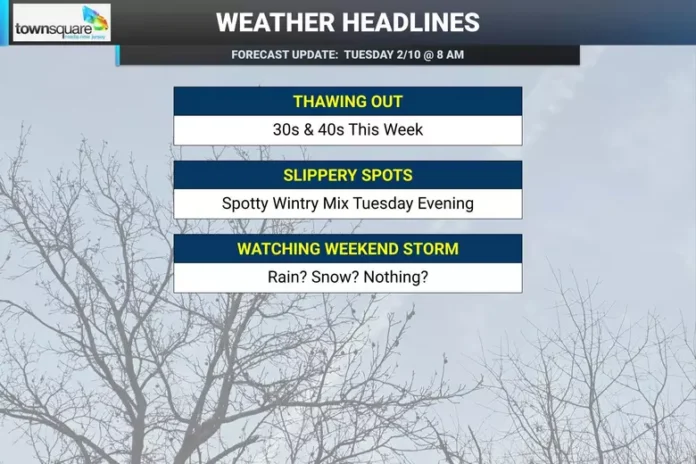
For the short term, the week ahead looks largely quiet. Aside from a weak disturbance expected to pass north of the state late Tuesday night into Wednesday, most of New Jersey should remain dry. There is a small chance that portions of North Jersey could briefly see a light wintry mix early Wednesday, but any impacts are expected to be minimal and limited primarily to slower travel during the early morning hours. Areas south of Interstate 80 are more likely to see any precipitation fall as rain.
The primary focus now turns to the upcoming weekend, particularly the February 14 through February 16 period. Medium-range forecast models continue to signal a broader storm system developing somewhere along the eastern United States, but the details remain highly uncertain. Small shifts in storm track and temperature profiles could dramatically change where rain transitions to snow across New Jersey.
At this stage, forecasters believe a rain-snow boundary may set up somewhere across the state. Exactly where that line forms will determine whether major population centers in the Philadelphia and New York City metro areas see primarily rain, a mix, or accumulating snow. Atmospheric indicators tied to the North Atlantic and Arctic oscillations suggest a temporary shift toward a more favorable storm pattern before returning to a colder background state, but confidence in the precise outcome remains low.
In straightforward terms, Monday is likely the final day of this stretch where many locations fail to rise above freezing. Beginning Tuesday, most of New Jersey should see afternoon temperatures reach the mid-30s, with parts of South Jersey and coastal areas potentially touching the lower 40s. Light wintry precipitation is possible late Tuesday night into early Wednesday for northern sections, though no major disruptions are expected.
Beyond that, the overall message for residents is simple: the state is done with the most brutal cold of the season, but not with winter itself. A short-lived mild stretch is possible after the weekend, followed by a return to near- or slightly below-average temperatures through much of late February and into early March.
From a seasonal perspective, New Jersey is now entering the heart of its statistically snowiest window. While the cold is easing, the atmosphere is becoming more favorable for moisture-rich systems that can still deliver accumulating snow, especially at night. Winter, in baseball terms, has only reached the middle innings, and the next few weeks remain very much in play for additional wintry weather across the state.


