State remains locked in a winter reset pattern through early next week before a brief thaw and a potential mid-February storm window
New Jersey remains stuck in what forecasters often describe as a “reloading trough” pattern, a repetitive winter setup that continues to recycle cold air into the region and delay any meaningful break from winter’s harshest stretch. That pattern is expected to persist through roughly Tuesday, February 10, marking the final phase of what has been the core of winter cold that has dominated the state since mid-January.
Although residents across South and Central Jersey have experienced a few slightly more tolerable afternoons this week, temperatures have still averaged just below normal, with daytime highs only briefly pushing above the freezing mark in many locations. The brief moderation has not been enough to qualify as a true warm-up, and the overall pattern remains firmly wintry.
That changes modestly late Friday as a fast-moving Alberta Clipper system approaches the state.
Thursday and Friday daytime will actually trend a bit colder than the past two days, with conditions similar to today but several degrees lower. Skies will remain dry through most of Friday, but attention turns to the evening commute as the clipper arrives around 5 p.m.
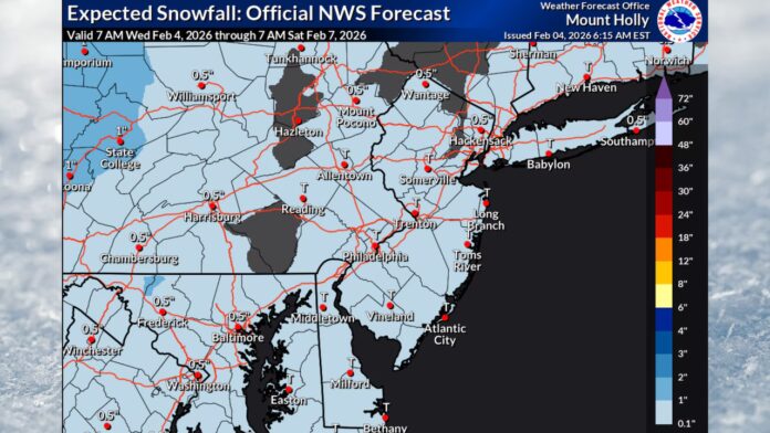
Light snow is expected to develop Friday evening and continue through the overnight hours, tapering off between 4 and 5 a.m. Saturday. This is not expected to be a significant winter storm, but it will be enough to create slippery travel conditions across much of the state, especially on untreated roads and elevated surfaces.
Current projections point to a general coating to about one inch of snow for most of New Jersey, with a few isolated pockets potentially reaching close to two inches. The most likely outcome remains minor accumulation, but even light snowfall combined with dropping temperatures will be enough to create localized travel concerns late Friday night and early Saturday morning.
Saturday will feel sharply different from Friday, not because of snow, but because of an advancing Arctic front.
Temperatures on Saturday are expected to peak unusually early in the day, likely by mid-morning or late morning, before falling steadily through the afternoon as colder air pours into the region. Winds will increase as the front passes, producing raw and increasingly uncomfortable conditions statewide.
By Saturday afternoon and evening, wind chills will plunge well below actual air temperatures, setting the stage for another round of bitter cold similar to what New Jersey experienced last week.
Saturday night into Sunday brings a renewed surge of Arctic air, reinforcing the deep winter feel. Sunday will remain cold and blustery, and the coldest night of the entire season is increasingly likely to occur Sunday night into early Monday morning, when clearing skies and light winds may allow temperatures to drop to their lowest levels of the winter so far.
The prolonged cold spell should finally begin to ease again on or around Tuesday, February 10, as a ridge of high pressure builds into the eastern United States. That shift will allow temperatures to rebound closer to seasonal norms and hold through at least Thursday or Friday, offering a short but meaningful break from the relentless cold.
However, attention is already turning to a developing storm signal for the February 14–15 timeframe.
Unlike the recent pattern, which has often featured overwhelming Arctic air suppressing storm systems south of the region, this upcoming signal suggests a more traditional winter storm setup. That means a potential rain-snow line somewhere across New Jersey rather than a system being forced well offshore or too far south to affect the state.
If this signal holds, portions of North, Central or South Jersey could end up on different sides of that precipitation boundary. At this stage, there is still significant uncertainty, and forecasters caution that model guidance will likely fluctuate dramatically over the next several days, producing a wide range of solutions that may populate automated forecast apps and social feeds.
The window will remain under casual monitoring through Monday, February 9. If the signal remains consistent after that point, more detailed tracking and accumulation projections will begin.
In plain terms for residents planning the next several days: expect slightly colder conditions than today through Thursday and Friday daytime. Light snow is possible statewide Friday evening after about 5 p.m. and should end by early Saturday morning, with a coating to around one inch being the most likely outcome, and isolated spots approaching two inches.
From Saturday through roughly Tuesday, New Jersey returns to a much colder regime, with Saturday afternoon through Sunday featuring the harshest wind chills. Sunday night into Monday morning may end up as the coldest night of the winter. Temperatures should finally relax again from Tuesday through the end of the workweek before attention turns to the potential mid-February storm window.
Residents are encouraged to stay aware of changing conditions and timing updates through Sunset Daily News’ ongoing weather report coverage for New Jersey.


