


Brief midweek thaw offers only short relief as another Arctic surge, light snow rounds, and coastal flooding concerns shape the week ahead across the Garden State
A sweeping satellite view of the eastern United States this week tells a striking story about winter’s persistence across New Jersey and much of the Northeast.
Recent NOAA GOES satellite imagery reveals an unusually broad and continuous snow cover stretching from the Mid-Atlantic through the Northeast and into the central Plains—an expanse that remains firmly in place after successive winter systems and an extended stretch of Arctic air. With last weekend’s snowpack still largely intact and fresh winter weather having affected the southern Mid-Atlantic over the weekend, the region now resembles a mid-season winter landscape more typical of earlier decades.
For New Jersey, the imagery serves as a visual reminder that the state is still fully capable of delivering a classic, high-impact winter—despite recent milder seasons.
So far this winter, temperatures have averaged below normal statewide, while snowfall has finished well above seasonal expectations in most areas. North Jersey remains the standout, running more than 10 inches above average in several communities. Central New Jersey is generally tracking around five inches above normal. South Jersey, while less extreme, is still coming in one to three inches above average for seasonal snowfall.
Those numbers are the product of a remarkably active stretch of winter weather dating back to mid-December.
A widespread storm on December 13 and 14 delivered a general four to eight inches across the state. On December 27, a warm air advection event produced another three to six inches in parts of North Jersey. The pattern intensified again during the January 16 through 18 period, when a two-part weekend system brought three to six inches to North Jersey on Friday as a shortwave rode an Arctic boundary, followed by two to five inches across much of Central and South Jersey on Sunday from a weak coastal low.
The winter reached its most disruptive point last weekend, when a powerful snow-to-ice system slammed the state. Totals ranged from 12 to 16 inches in North Jersey, eight to 12 inches in Central Jersey, and four to eight inches in South Jersey. In the days since, a few narrow snow bands narrowly missed portions of southeastern New Jersey that could easily have added another one to four inches. Instead, most locations only saw scattered snow showers and flurries with little accumulation.
Layered on top of those larger events were multiple “nickel-and-dime” systems—fast-moving clippers and lake-effect driven snow showers—that frequently coated roads and sidewalks, keeping snow cover fresh and persistent.
After nearly three straight weeks of near-constant storm tracking and deep cold, residents across the state are finally seeing a short break.
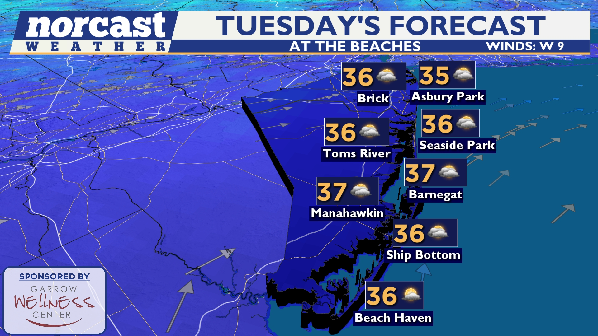
Today, Tuesday, February 3, marks the first meaningful pause in a nine-day Arctic freeze. Temperatures across South Jersey, including the Cherry Hill area, have climbed just above freezing under partly sunny skies. Afternoon highs are reaching the mid-30s, with a noticeably less biting feel compared to the sub-20-degree readings that dominated much of the past week.
Tonight turns mostly cloudy, with lows settling near 20 degrees.
That temporary moderation will continue through Thursday. Afternoon temperatures are expected to rise above freezing during peak daytime hours, offering a much-needed opportunity for crews and property owners to chip away at stubborn ice and refreeze-prone runoff left behind by last weekend’s storm.
Still, winter is far from finished.
Two weak snow-producing systems are expected to pass through New Jersey before the next Arctic outbreak arrives.
The first system arrives late tonight and continues into early Wednesday morning. It is a weak disturbance and is expected to favor South Jersey. Most areas will see little more than flurries or a light dusting, but isolated spots could approach an inch. With colder overnight temperatures, snow-to-liquid ratios will be higher, meaning even light precipitation could accumulate more efficiently than usual. While significant impacts are not anticipated, slick spots may develop for the Wednesday morning commute.
The second system arrives on Friday in the form of a fast-moving clipper and accompanying Arctic front. While forecast confidence on exact placement and intensity will improve over the next several days, the current expectation points to scattered snow showers and snow squalls across much of the state. Gusty winds of 30 to 40 miles per hour are also possible, creating brief visibility reductions and localized travel disruptions.
Neither system is expected to trigger widespread closures or major delays. However, both have the potential to produce quick coatings that could catch drivers off guard—particularly early Wednesday morning and again during the day Friday.
More concerning than the snow itself is what follows.
Another surge of Arctic air is poised to spill into New Jersey behind Friday’s clipper. By Saturday and Sunday, daytime highs are expected to struggle to reach the teens. Wind chills may drop as low as 15 degrees below zero in some locations, creating dangerously cold conditions for anyone spending extended time outdoors.
The cold air is expected to linger into early next week.
Along the coast, the cold pattern is being paired with elevated tidal concerns. The National Weather Service has issued a coastal flood advisory for portions of the Jersey Shore, citing the potential for minor flooding during high-tide cycles early this week. While significant storm surge is not expected, repeated minor flooding can still affect low-lying roadways, bayside neighborhoods, and parking areas near marinas and inlets.
Meteorologists are also closely monitoring larger-scale atmospheric signals that could influence the second half of February.
A recent sudden stratospheric warming event in the upper atmosphere has disrupted the polar circulation aloft, increasing the likelihood of a split in the polar vortex in the coming days. Historically, these stratospheric disruptions often take one to two weeks to translate into colder and more active weather patterns closer to the surface. That timing aligns closely with the return of Arctic air this weekend and supports the idea of an active and wintry pattern continuing into the Valentine’s Day time frame.
In plain terms, New Jersey is entering a brief window of relative calm rather than a true seasonal shift.
Temperatures will moderate into the low and mid-30s during the afternoons through Thursday, while still dropping below freezing each night. The overall pattern remains mostly dry, aside from two chances for light snow—late tonight into early Wednesday, mainly across South Jersey, and again on Friday statewide.
Neither event currently appears disruptive enough to force closures or widespread schedule changes, but both could generate enough light snow to produce slick travel during peak periods.
By late Friday and into the weekend, Arctic air returns in force, setting up another stretch of bitterly cold weather across the Garden State.
Winter may be showing brief signs of easing, but the satellite picture, snow totals, and large-scale atmospheric signals all point to a season that is still very much alive—and capable of delivering more true winter weather in the days ahead. For continuing updates and localized tracking, readers can follow Sunset Daily’s ongoing weather report coverage throughout the week.

