


Polar plunge locks in rare freeze across the Garden State, closing parks, disrupting travel, and pushing temperatures toward record territory
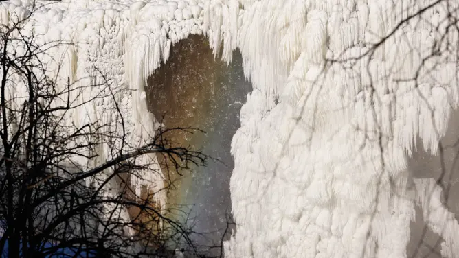
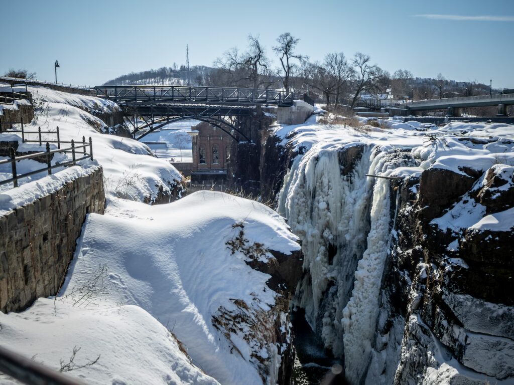

PATERSON — The roar of the Paterson Great Falls has been muted into something almost unreal.
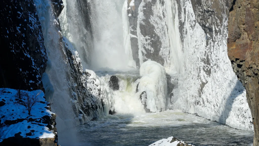
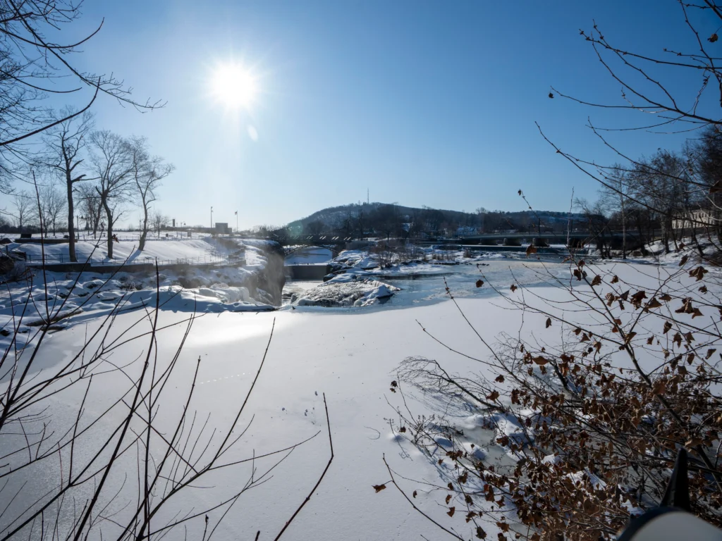
As of January 28, 2026, New Jersey’s most iconic natural landmark is locked in ice, transformed into what visitors are already calling a “frozen masterpiece” as a relentless wave of Arctic air tightens its grip across the region. Thick sheets of ice cling to the basalt cliffs, mist freezes in midair, and only narrow channels of dark, fast-moving water remain visible beneath the cascading white and blue formations.
The dramatic transformation comes after a prolonged stretch of sub-freezing temperatures driven by a destabilized and weakened polar vortex pattern that has allowed frigid air from the Arctic to spill deep into the northeastern United States. Meteorologists say the prolonged duration of this cold snap — not just its intensity — is what makes the current event especially significant for New Jersey.
Across the state, temperatures have struggled to climb out of the teens during the day, while overnight lows have repeatedly plunged into the single digits.
In Newark, forecasters are tracking overnight lows near 3 degrees, a level that would match a long-standing cold record dating back to 1935. In Trenton, temperatures are projected to fall to zero or below, placing the capital region on the brink of breaking a daily low-temperature record set in 2014.
For residents seeking localized updates and advisories, the latest statewide conditions and alerts can be found through the Sunset Daily New Jersey weather report coverage.
The impact of the cold is not limited to weather statistics.
Along the Hudson River, massive ice floes have formed and begun drifting through the shipping channels and ferry corridors. The ice buildup has become severe enough to temporarily suspend portions of NYC Ferry service, underscoring how far-reaching the effects of this freeze have become for regional transportation and commerce.
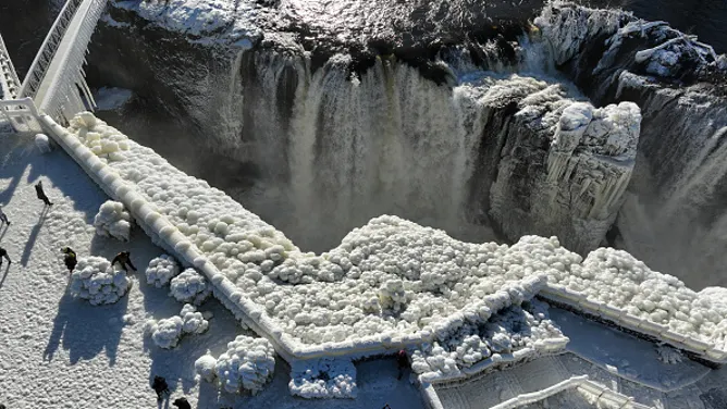
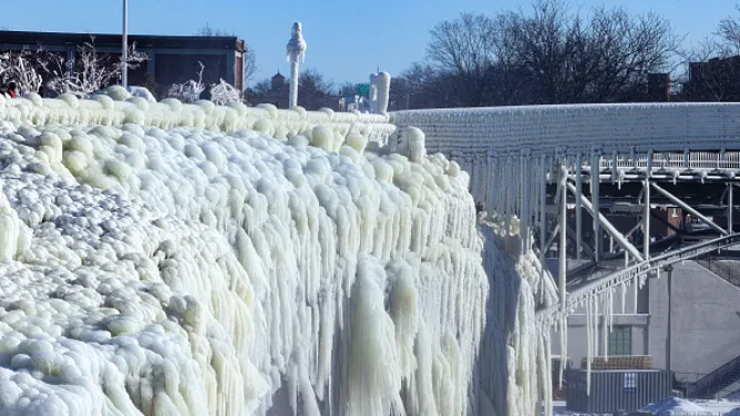
Here in Passaic County, the Paterson Great Falls National Historical Park has become one of the most visually striking — and potentially dangerous — places to experience the cold snap firsthand.
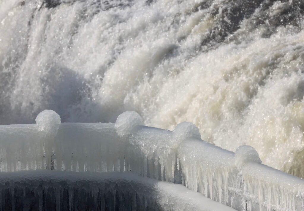
Park officials have implemented weather-related closures for several park buildings and select overlook areas, citing rapidly forming ice, falling frozen spray, and treacherous walking surfaces. Rangers warn that even well-maintained paths can develop invisible “black ice” within minutes as water vapor from the falls settles and freezes along railings, staircases, and observation decks.
The visual effect, however, is extraordinary.
Normally, more than two billion gallons of water surge over the Great Falls each day. This week, large portions of the cascade appear sculpted into frozen tiers and curtains, with thick icicles stretching downward from the rock walls and the steel pedestrian bridge. Wind gusts push ice crystals across the gorge, giving the scene an almost alpine character rarely associated with North Jersey.
Local historians note that while the falls have partially frozen many times in the past, full or near-full freeze events remain relatively uncommon and typically require several consecutive days of deep cold combined with minimal solar warming. The current pattern — featuring clear overnight skies and steady Arctic airflow — has created ideal conditions for widespread ice formation.
Beyond the spectacle, state officials are emphasizing that the cold wave poses serious public safety concerns.
Emergency management agencies are urging residents to limit outdoor exposure, especially during overnight and early morning hours when wind chills can fall well below zero. Frostbite can occur in as little as 15 to 30 minutes under these conditions, particularly on exposed skin. Seniors, young children, and those experiencing housing insecurity face the greatest risks.
Homeowners are also being advised to protect exposed pipes, allow slow drips from vulnerable faucets, and monitor heating systems carefully as prolonged cold places heavy strain on residential infrastructure. Fire departments across North Jersey have already responded to a spike in frozen and burst water lines as temperatures remained below freezing for multiple days in a row.
For drivers, untreated side roads and shaded intersections remain a major concern. Even during daylight hours, road surfaces can remain frozen where snowmelt refreezes after sunset. Officials urge motorists to slow down, increase following distance, and watch for ice near bridges and overpasses, which tend to freeze more quickly than surrounding pavement.
While the Great Falls has become a popular destination for photographers this week, park officials stress that visitors should view the scene only from open, designated areas and respect all posted closures. Venturing beyond safety barriers or attempting to access the river’s edge can be extremely dangerous, especially as shifting ice slabs and rising water beneath frozen surfaces create unpredictable conditions.
For now, New Jersey remains firmly under the influence of the Arctic air mass, and forecasters say the cold is expected to linger through the end of the week, keeping the falls locked in ice and pushing heating demand to its highest levels of the season.
As the state endures one of its most visually dramatic cold spells in years, the frozen Paterson Great Falls stands as a powerful reminder of both the beauty — and the force — of winter in the Garden State.
Deep Freeze Grips New Jersey as Arctic Air Collides With Offshore Nor’easter Threat. Brutal cold marks the state’s coldest day in years while forecasters closely monitor powerful coastal storm and heightened flooding risk along the Jersey Shore
New Jersey is enduring its coldest day in more than three years as an intense Arctic air mass settles across the region, bringing dangerous wind chills, near-record overnight lows, and growing concern over a powerful offshore storm system expected to influence conditions through the weekend.
Friday, January 30, 2026, is shaping up to be one of the harshest winter days residents have experienced in recent memory. Skies will remain mostly sunny statewide, but the sunshine will offer little relief. Afternoon high temperatures are expected to stall in the upper teens, generally between 17 and 19 degrees across much of the state.
Persistent northwest winds gusting near 15 miles per hour will drive “feels-like” temperatures into the single digits and, at times, below zero throughout the day. Even brief exposure outdoors can become hazardous under these conditions. Residents looking for localized advisories and rolling updates are encouraged to follow ongoing New Jersey weather coverage through the Sunset Daily weather report section.
By Friday night, the cold intensifies further. Forecast guidance points to overnight lows dropping to around 5 degrees in Newark, with parts of central and southern New Jersey, including Trenton and surrounding communities, flirting with zero or even slightly below. These temperatures place several long-standing daily records within reach and underscore the historic nature of this cold spell.
The dangerous cold will not be short-lived.
Saturday is expected to remain mostly sunny but sharply cold, with daytime highs recovering only slightly into the lower 20s, generally between 20 and 24 degrees. Wind chills will remain in the single digits for much of the day, particularly during the morning hours.
At the same time, meteorologists are closely monitoring Winter Storm Gianna, a powerful nor’easter currently organizing well offshore of the Mid-Atlantic. Recent model guidance continues to push the core of the storm farther out to sea, significantly lowering the likelihood of a major snow event for most of New Jersey.
Under the latest projections, snowfall from Saturday night into Sunday is expected to be limited primarily to the far eastern portion of the state, especially areas east of the Garden State Parkway. Even there, totals are increasingly forecast to range from a trace to around three inches, with many inland communities seeing little more than flurries or passing snow showers.
The uncertainty surrounding this storm, however, remains unusually high.
Upper-level atmospheric patterns show a fast-moving trough with a less favorable orientation for driving precipitation inland. In addition, the developing surface low is expected to deepen rapidly over the open Atlantic, potentially dropping below 980 millibars in central pressure. Complicating matters further, guidance suggests the presence of multiple strong coastal low centers interacting offshore — a scenario that can produce complex storm behavior similar to the Fujiwhara effect, where nearby storm systems influence each other’s track and intensity.
For forecasters, this creates what is often referred to as a “gray forecast” — a situation where the most likely outcome is minimal snowfall, but even small shifts in storm position or timing could dramatically alter local impacts.
In practical terms, a deviation of only 30 to 40 miles in the storm’s track could determine whether portions of southeastern New Jersey see little more than brief snow showers or experience a burst of heavier snow. With the overall storm spanning well over a thousand miles in diameter, that margin is meteorologically small, yet critical for communities along the coast.
For now, the most reasonable expectation for Saturday night through much of Sunday remains a light grazing of snow showers for far southeastern New Jersey and the immediate coastline — or potentially no measurable snowfall at all.
While the snow forecast remains conservative, confidence is much higher regarding coastal impacts.
Strong onshore winds are expected to develop late Saturday and persist into Sunday, with gusts approaching 50 miles per hour along the immediate shoreline and 30 to 40 miles per hour farther inland. These winds, combined with astronomical influences from a near-full moon, are likely to drive elevated water levels during Sunday’s high tide cycles.
Coastal communities from Monmouth County through Cape May are expected to experience high-end minor to low-end moderate coastal flooding, affecting oceanfront areas, inlets, back bays, and tidal estuaries. Portions of Delaware Bay may also see elevated water levels, though impacts there are expected to be less severe than along the open ocean shoreline.
What makes this event especially concerning is the extreme cold already in place.
Large areas of bay and backwater surfaces remain frozen. As tidal waters rise, sheets of ice can lift with the water and shift against docks, pilings, and bulkheads, increasing the risk of structural damage. When the tide recedes, water left behind on roadways and low-lying properties is expected to freeze rapidly, creating hazardous ice-covered streets and driveways.
In addition, the combination of powerful winds and sub-20-degree air temperatures is likely to generate dramatic ocean spray freeze along exposed coastal structures. This phenomenon can coat railings, walkways, and even utility infrastructure with thick ice, raising concerns for localized power disruptions and dangerous conditions near jetties and boardwalks.
Emergency officials are urging residents in flood-prone coastal neighborhoods to prepare for rapidly changing conditions on Sunday, especially around the morning and evening high tides, when water levels are expected to peak.
Across the rest of the state, a Cold Weather Advisory remains in effect for all 21 counties through Saturday morning due to the elevated risk of frostbite and hypothermia. Health officials warn that exposed skin can develop frostbite in as little as 15 to 30 minutes under these wind chill values.
Travel remains another major concern.
Cleanup efforts continue across many communities following the recent 17-inch snowfall earlier this week, and the persistent cold is preventing effective melting. Numerous school districts and state offices announced delayed openings on Friday as road crews continue to clear secondary streets and sidewalks that remain packed with snow and ice.
Transportation officials are also warning drivers to use caution on bridges, overpasses, and shaded roadways, where refreezing is likely even during daylight hours.
While the current data strongly favors a miss or near-miss from Winter Storm Gianna in terms of snowfall, forecasters stress that the offshore storm’s intensity and evolving structure warrant close monitoring through Saturday night and Sunday.
In plain terms, most of New Jersey should expect extreme cold, gusty winds, and little to no snow from this system. The greater threat lies along the coast, where powerful winds, elevated tides, frozen bays, and ice-laden spray could combine to produce a uniquely hazardous winter setup rarely seen in the region.
Residents statewide are encouraged to remain alert, follow local advisories, and prepare for rapidly changing conditions as one of the coldest and most complex winter weekends in years unfolds across New Jersey.

