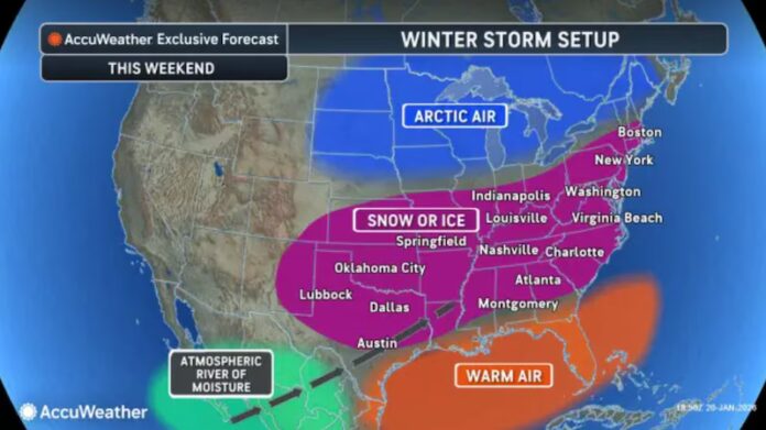
Record cold locks down the state while forecasters track a powerful coastal storm with rising confidence. New Jersey has entered the kind of winter stretch that defines a season — biting Arctic air, relentless cold, and the growing possibility of a high-impact snowstorm on the horizon. Residents across the state are waking up to subfreezing mornings, stinging wind chills, and the kind of cold that turns ordinary errands into calculated missions. At the same time, meteorologists are watching the Atlantic closely, where a developing coastal system could deliver a significant winter storm as the weekend unfolds.
Early morning temperatures across the region have plunged into the teens, with wind chill values making it feel closer to single digits. A statewide cold weather advisory remains in effect as gusty winds drag perceived temperatures toward zero and below. Skies began the day with brief sunshine, but increasing cloud cover is signaling that the atmosphere is shifting toward a more active pattern. This is not a short cold snap — it is a sustained Arctic intrusion that will hold its grip through the end of the week.
Thursday is expected to bring even colder conditions, with daytime highs struggling to reach the low 20s and overnight temperatures dipping toward the single digits. By Friday morning, some inland communities may approach zero or below, marking what could be the coldest stretch of the season so far. These extreme temperatures will ensure that any existing snowpack, slush, or standing moisture on roadways will refreeze into hazardous black ice, particularly overnight and during early-morning commutes.
While the cold itself is commanding attention, the larger story is developing offshore. Forecast models are increasingly signaling the formation of a strong coastal low late Saturday into Sunday. Though still several days away, the guidance has begun to show tighter agreement in storm track and intensity — a sign that confidence in at least some level of winter impact is increasing.
Meteorologists tracking the system note that this is not a simple storm. It is a complex interaction between northern and southern atmospheric energy streams, which must align precisely to draw a rapidly intensifying low-pressure system close enough to the coast to produce heavy snowfall. When this interaction occurs efficiently, the result is a phenomenon known in meteorological circles as rapid intensification — the type of storm that can produce heavy bands of snow, strong winds, and coastal impacts in a short period of time.
Current projections suggest a late Saturday night onset, with snowfall potential continuing through Sunday and possibly into early Monday. Coastal and I-95 corridor communities are currently positioned within the zone where heavier snow bands could develop if the storm reaches full strength. Inland areas may see lighter totals if the storm tracks slightly offshore, while a small shift closer to the coast would expand significant snowfall deeper into the state. This delicate balance is why forecasters are stressing caution — small timing changes in the upper atmosphere can mean the difference between a near-miss and a major winter event.
What adds credibility to this developing scenario is the tightening cluster of storm-track guidance. Earlier model runs showed a broader range of outcomes. Now, newer data sets are narrowing toward a similar offshore intensification point, suggesting the atmospheric ingredients are becoming more organized. While uncertainty remains, the probability of a meaningful snow event has increased compared to earlier outlooks.
Despite the rising confidence, weather experts continue to emphasize that no single automated app forecast tells the whole story. Complex storm setups like this require interpretation of upper-atmospheric dynamics, not just surface temperature and precipitation output. That deeper analysis is what allows forecasters to assess whether energy streams will phase correctly, whether the low will deepen rapidly enough, and whether steering currents will bend the storm back toward the coast or let it drift harmlessly out to sea.
In practical terms, New Jersey residents should prepare for two immediate realities: persistent dangerous cold through the end of the week and the growing likelihood of a winter storm late in the weekend. Households should protect exposed pipes, ensure heating systems are functioning properly, check emergency supplies, and monitor travel conditions closely. Drivers should assume untreated roads will remain icy well into daylight hours, even without fresh snow.
As the weekend approaches, updated projections will refine snowfall expectations, wind potential, and any coastal flooding concerns. For continuous local forecasting and real-time tracking, readers can follow the Sunset Daily News weather report coverage dedicated to New Jersey’s evolving winter conditions.
For now, the message is clear. The Arctic air is locked in. The ocean storm is organizing. And New Jersey is once again reminded that winter along the Mid-Atlantic coast is never just cold — it is dynamic, high-stakes, and always capable of changing quickly.


