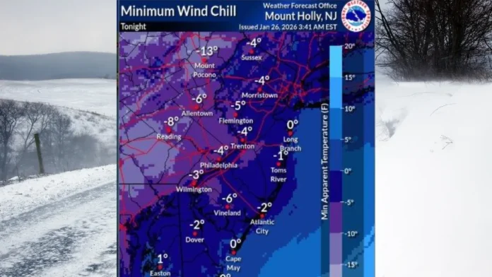
Historic cold follows major winter storm while forecasters track a potential weekend nor’easter that could once again reshape the state’s weather landscape
New Jersey is locked in the coldest stretch of the winter season as an arctic air mass pours across the region following a powerful snowstorm that buried parts of the state under nearly a foot and a half of snow. What began as a dramatic weekend storm has now evolved into a prolonged deep freeze, creating dangerous outdoor conditions, icy travel hazards, and mounting anticipation over another possible coastal storm looming on the horizon.
Sunshine and bright skies may offer a visual calm today, but temperatures tell a different story. Daytime readings are struggling to climb out of the lower 20s, with many communities seeing highs that barely reach the low-to-mid 20-degree range. As the sun sets, clear skies will allow temperatures to plunge even further, dropping into the single digits statewide. In elevated areas of northwest New Jersey, readings may fall below zero overnight. Wind chills between negative 10 and negative 15 degrees are creating a serious risk of frostbite and hypothermia, prompting cold weather advisories that remain in effect into midweek.
This is not a brief cold snap. Forecasters indicate that the arctic high pressure system responsible for this outbreak will remain anchored over the region through the end of the week. Wednesday continues the frigid trend, with daytime temperatures hovering in the low-to-mid 20s and overnight lows again sinking into the single digits. Thursday appears even colder, with potential near-record lows as nighttime readings dip toward the mid-single digits. Friday offers little relief, maintaining subfreezing daytime highs and bitter overnight cold that keeps roadways icy and snowpack frozen in place.
The storm that delivered the weekend snowfall was not an ordinary winter system. Atmospheric patterns aligned perfectly to funnel polar air southward while a phased storm system tracked up the East Coast, drawing moisture into an environment primed for heavy snow. Central and northern portions of the state experienced major accumulations, while southern areas saw intense snowfall before any changeover. The result was a high-impact winter event that triggered a statewide emergency declaration, suspended transit operations, and left lingering travel concerns even after plows cleared primary roads.
Now, as the atmosphere resets, attention turns to the next potential chapter in this volatile winter pattern. Global forecast models are signaling the development of another powerful coastal storm late Saturday into Sunday. Early indications suggest a classic nor’easter setup, with a surface low forming in the southern United States and tracking northward along the East Coast. Whether that storm stays offshore or hugs closer to the coastline will determine if New Jersey sees another round of significant snow, a mixed precipitation event, or a near-miss that spares the state.
At this stage, confidence in the exact track remains moderate, but the broader signal for storm development is strong. Even a modest shift in the upper-level pattern could pull the system toward the coast, opening the door for additional snow accumulations and gusty winds. Coastal communities could also face the risk of tidal flooding if the storm intensifies near shore. Forecast guidance continues to fluctuate run-to-run, a normal trait when a system remains several days away, but the pattern itself supports the possibility of another impactful winter event.
For now, the immediate concern remains the cold. With temperatures staying well below freezing all week, untreated roads will remain icy, snowbanks will not melt, and exposed skin can freeze in minutes under strong winds. Residents are urged to limit prolonged outdoor exposure, ensure pets are protected, and check heating systems as energy demand spikes across the region.
New Jersey’s winter story is far from over. A punishing cold wave has settled in, and the potential for another major snowmaker looms as the weekend approaches. As conditions evolve, updated Weather Report coverage will continue tracking temperature trends, storm developments, and travel impacts statewide.
One thing is certain: the Garden State remains in the heart of winter’s most aggressive phase, and the coming days will test both endurance and preparedness across every corner of New Jersey.


