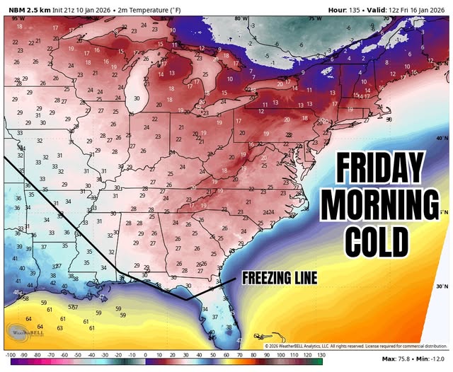
New Jersey is enjoying a brief reprieve from winter’s grip today, January 13, 2026, with tranquil and relatively mild conditions giving residents a mid-winter break before a significant cold spell arrives later this week. Temperatures this morning started in the 20s across most of the state, climbing into the mid-40s to low 50s by afternoon under mostly sunny skies that will gradually give way to increasing clouds. Winds are light from the south to southwest at 5–15 mph, with occasional gusts reaching 20–30 mph in exposed areas.
Tonight, skies will become mostly cloudy, with a slight chance of stray showers after 1:00 a.m. Temperatures remain mild for mid-January, holding near 40°F. But forecasters are closely monitoring a series of powerful upper-level disturbances that will bring dramatic changes starting tomorrow evening and into the weekend.
The first major system arrives Wednesday night into Thursday, pushing an arctic cold front through the region. Residents can expect blustery conditions and temperatures struggling to reach the mid-30s on Thursday, with wind chills dropping into the teens by Friday morning. Precipitation may begin as rain Thursday morning but is likely to transition to snow as temperatures fall, producing scattered snow showers capable of accumulating up to an inch or two across parts of the state. Despite the presence of strong upper-level storm energy, the timing and interaction of multiple troughs in the jet stream make a significant snowstorm unlikely for this period.
Meteorologists are tracking two additional upper-level systems for later this month, with signals for January 18–19 and January 22–24 still active. These systems contain considerable storm energy, but precise timing is critical. If the subsequent troughs slow or phase correctly, there is potential for more substantial snow events. Currently, the energy of the first system is expected to be sheared out by the following troughs, leaving New Jersey with lighter snowfall Thursday into Friday while holding out the possibility of more significant accumulation later in the month.
Residents should remain alert for rapidly changing winter conditions. Thursday morning will likely see temperatures fall steadily as the arctic front passes, turning any morning rain to snow by Thursday evening. Strong upper-level dynamics are in play, but without optimal phasing, snow accumulations will likely remain modest. The weekend brings another storm system, with a 40% chance of light snow showers Saturday night into Sunday, keeping northern and central New Jersey in a continued pattern of cold and variable winter weather.
The pattern for the next two weeks appears to be a series of consecutive troughs, maintaining consistently cold conditions with minimal warming. While Thursday’s snow event is expected to be minor, snow enthusiasts can monitor later signals for January 18–19 and January 22–24, which may offer more meaningful winter weather. Forecasters emphasize that the next 72 hours will provide more clarity for Thursday and Friday’s precipitation, and updates will continue as models converge on the exact timing and intensity of snowfall.
Stay informed with ongoing updates on New Jersey’s winter weather and emerging storm signals through the Sunset Daily News [Weather Report](Weather Report) section, where detailed forecasts, snow tracking, and expert analysis provide residents with the information needed to plan for arctic conditions and potential snow events.
For now, New Jerseyans can enjoy today’s mild respite, but preparation for Thursday’s cold blast and scattered snow showers is advised, with temperatures dropping sharply as the state enters a week of challenging winter conditions.


