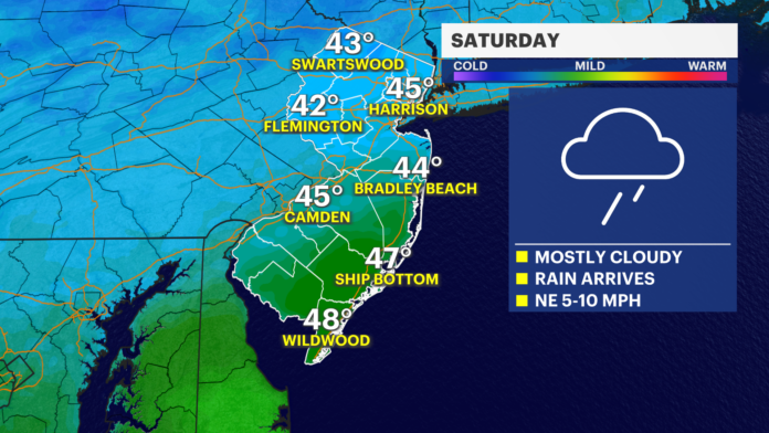
New Jersey residents can expect a shift in weather conditions this weekend, as a brief mild stretch gives way to periods of rainfall and colder air early next week. Friday’s weather brought temperatures in the mid-40s to mid-50s across the state, with cloudy skies dominating from northern to southern regions. After weeks of colder temperatures since late November, this mild break has been a welcome relief for residents, many of whom took advantage of the warmer air to enjoy the outdoors.
Rain is expected to develop between midday and mid-afternoon on Friday, with heavier showers arriving later in the evening. Localized ponding on roadways may occur, particularly in urban areas and spots with limited drainage. While the total rainfall from Friday evening into Saturday night is projected to reach at least a quarter-inch statewide, some southern and central regions may see totals closer to half an inch, with isolated areas potentially receiving one to two inches. The rain is expected to taper off late Saturday night or early Sunday morning.
Saturday will see the main batch of rainfall between 9 a.m. and 9 p.m., providing the heaviest precipitation for the weekend. Conditions should improve overnight into Sunday, ahead of a cold front moving through mid- to late-morning. The front is expected to push temperatures down sharply on Sunday, with highs likely occurring in the morning hours rather than the typical midday peak. Following the front, temperatures are forecast to fall into the 35-45 degree range across the state, accompanied by stiff west-to-northwest winds. Most areas will dip below freezing Sunday night into Monday.
Early next week, a “hurry up and wait” pattern is anticipated. Monday through Wednesday will feature near-average temperatures, though the air mass will remain dry and moderately cold. A second cold front is projected to arrive Wednesday night into Thursday morning, bringing colder conditions and the potential for sub-freezing highs on Thursday. Overnight lows Thursday into Friday morning are expected to range between 10 and 20 degrees statewide, with dry conditions likely through Friday morning.
Meteorologists are closely monitoring the January 15-20 period, which could bring more active winter weather. A shift in the Eastern Pacific Oscillation is expected to transition the region from the current mild pattern to a trough across the eastern United States. Early signals point to two potential waves of energy impacting the Mid-Atlantic, around January 15-16 and January 18-19. While exact timing and precipitation details remain uncertain, these periods are being watched for potential coastal snow events or other impactful winter weather.
In practical terms, the next few days will feature mild but rainy conditions through Saturday, followed by a cold front Sunday that will lower temperatures and bring brisk winds. Next week will see a return to colder, mostly dry conditions, with a more intense winter pattern developing midweek. Residents should remain attentive to updated forecasts, particularly as potential snowstorm signals for mid- and late-January continue to evolve.
For ongoing updates and detailed weather reports across the state, readers can visit Sunset Daily News’ weather report section.
With varying rainfall amounts this weekend and colder air on the horizon, New Jerseyans are advised to plan accordingly for travel and outdoor activity, while keeping an eye on potential winter developments in the second half of January.


