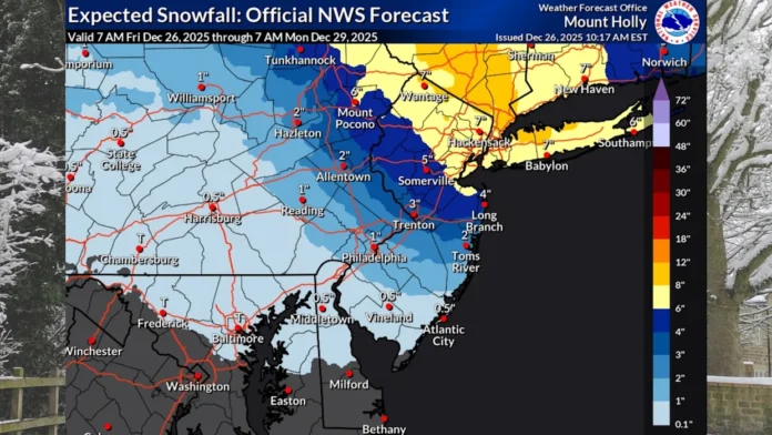
New Jersey experienced a complex winter system yesterday as a combination of snow and sleet moved through the region. The storm arrived on schedule by late afternoon, but warm air advection from the southwest created challenging conditions, especially across Northern New Jersey. This warm layer in the lower atmosphere caused precipitation to fluctuate between snow and sleet, creating a seesaw effect where heavier bursts of precipitation temporarily produced all-snow conditions while lighter periods allowed sleet to dominate. This dynamic explains why some areas went back and forth rather than transitioning neatly from snow to ice, leading forecasters to emphasize the uncertainty of the event.
Southern and Central New Jersey saw minimal snowfall, with only a light dusting to an inch as originally expected. Ice accumulation, however, verified well against forecasts, creating slick conditions on untreated roads. Northern New Jersey zones experienced the largest forecast discrepancies. While these areas were initially affected by a mix of snow and ice, a dry slot in precipitation—caused by atmospheric subsidence linked to an intense jet streak over New York State and Coastal New England—reduced snowfall by 3 to 6 inches in some communities. Once the dry slot refilled after 3 a.m., Northern New Jersey ended up with 1-3 inches in some zones and 3-5 inches in others, still below the originally projected totals. Had the dry slot not occurred, snowfall totals could have reached 6-10 inches north of I-78 and extending down into Monmouth County.
This morning, an inverted trough continues to deliver light snow showers across parts of Central and Southern New Jersey. While accumulations are minimal—generally a fresh coating to an inch—the additional layer of snow over the icy crust will add to travel hazards until it gradually moves toward the coast. Temperatures will remain at or below freezing for much of the state today, allowing some ice melt in exposed areas, but untreated roads are likely to remain slick, especially tonight. Drivers should exercise caution as overnight lows drop into the teens and low twenties across Northern and Southern New Jersey.
Looking ahead to Sunday, a warm front will bring rain across most of the state, with daytime highs in the upper 30s to mid-40s. Northwestern New Jersey may experience brief periods of freezing rain if the rain falls early enough on still-cold surfaces, though temperatures are expected to rise above freezing later in the morning. The remainder of the state will see mostly rain showers. By Sunday night into Monday, milder conditions will prevail, with temperatures well above freezing under warm sector flow. A cold front is expected Monday night, bringing cooler temperatures for Tuesday and Wednesday with no additional significant weather disturbances forecasted for the remainder of 2025.
As 2026 approaches, early signals indicate a continuation of active weather patterns. The recent low-pressure system influencing Sunday’s warm front and Monday’s cold front is expected to alter the jet stream into a Western U.S. ridge and Eastern U.S. trough, with Greenland blocking reflected in oscillation indices. Three potential signals are currently being monitored: a short-range wave or weak coastal storm around January 1-2, a mid-range coastal storm near January 6, and a longer-range Miller-A storm potential between January 10-12. While the latter two remain speculative, the January 1-2 signal will receive closer attention if model trends continue over the weekend.
For ongoing updates and regional winter weather coverage, readers can access the latest New Jersey weather reports through Sunset Daily’s Weather Report section.


