


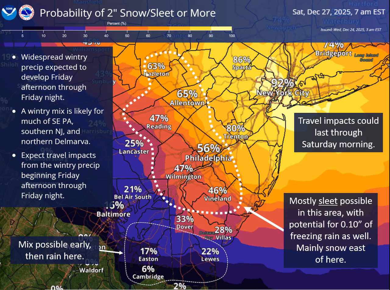
New Jersey is preparing for a dynamic winter weather event that is expected to unfold late Friday into the early hours of Saturday, bringing a complex mix of snow, sleet, freezing rain, and rain across the state. Forecasters are closely monitoring the evolving atmospheric pattern, which is setting the stage for a narrow but highly impactful storm corridor that could sharply divide snowfall totals and precipitation types by region.
A strong jet stream configuration stretching from western Canada through the northern United States and dipping into the Mid-Atlantic is acting as the primary steering mechanism for this system. The developing storm will track eastward along a narrow thermal boundary positioned near the Delmarva Peninsula before moving offshore. As the system advances, it will interact with additional atmospheric energy south of the Great Lakes, generating a zone of overrunning precipitation that will spread northeastward into New Jersey.
This setup creates what meteorologists describe as a classic “battleground” storm, where small shifts in temperature at various levels of the atmosphere can dramatically change what falls from the sky. Areas positioned well to the northeast of the thermal boundary are likely to experience mostly snow. Locations well to the southwest are expected to see a transition to rain or a rain-dominant mix. The greatest uncertainty lies in the central corridor of the state, where alternating layers of cold and warm air aloft could produce periods of sleet or freezing rain that limit snow accumulation while increasing the risk of slippery travel.
Adding to the complexity is a surge of cold air flowing into the region from a high-pressure system situated to the north. This will reinforce colder surface temperatures as precipitation begins, increasing the potential for wintry conditions even in areas that might otherwise lean warmer. The overnight timing further amplifies the risk, as the coldest temperatures of the day typically occur after sunset.
Current projections suggest that precipitation will begin around 5 p.m. Friday and taper off by approximately 5 a.m. Saturday. The most intense period of snowfall and mixed precipitation is expected between roughly 7 p.m. Friday and 3 a.m. Saturday, when snowfall rates and icing potential could be at their peak. While forecast models continue to vary on exact accumulation totals, the overall confidence is high that parts of the state will experience hazardous travel conditions during this window.
Travel conditions during the day Thursday and Friday ahead of the storm are expected to remain relatively favorable, with milder daytime temperatures and minimal disruption. However, colder air will steadily return by Friday afternoon, setting the stage for the evening deterioration.
Residents are encouraged to monitor updates closely as forecasters refine snowfall and icing projections over the next 24 to 48 hours. Small adjustments in the storm track could significantly alter which communities see plowable snow versus more disruptive ice.
For continuing updates, advisories, and localized forecasts, visit our weather report section, where the latest information for New Jersey communities is updated regularly.

