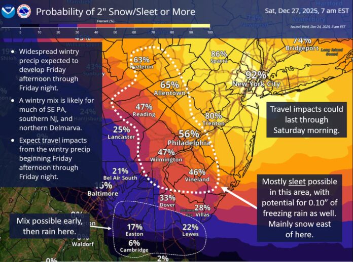
A complex weather pattern is taking shape across the Mid-Atlantic, positioning New Jersey for a potentially disruptive round of winter conditions as the final week of December unfolds. Meteorologists are closely monitoring a dynamic jet stream configuration that is creating a sharp temperature divide across eastern North America, setting up the ingredients for a multi-type winter event later this week.
The primary atmospheric boundary is currently sweeping west to east across southern Canada before dipping through the eastern Great Lakes and stretching into the Mid-Atlantic region. This boundary separates colder air to the north from milder air to the south, and it has become the focal point for developing storm systems. Over the next several days, this dividing line is expected to shift back and forth as cold fronts and warm fronts pass through the region.
A high-pressure system building over southern Canada will play a critical role in determining where that boundary settles. Forecast guidance suggests it will gradually move eastward and may force the cold air line southward into New Jersey. Current projections place this dividing zone somewhere between South and Central Jersey, though small changes in the strength of the high could push it farther north or south. That subtle movement will ultimately dictate who sees snow, who deals with ice, and where rain dominates.
Once the boundary is established, a new storm system is expected to track along it late Friday into early Saturday. This setup creates a classic winter “battleground” scenario, where snow is favored to the north, rain to the south, and a potentially hazardous mix of sleet and freezing rain develops in between. Northern counties, particularly in the northeastern part of the state, are currently in the most favorable position for predominantly snow. Farther south, communities may see a more complex progression of precipitation types, with ice and rain possibly finishing the event.
Timing is another critical factor. The developing system is projected to bring precipitation into New Jersey Friday evening, with the bulk of the activity occurring overnight into early Saturday morning. The heaviest conditions are most likely to fall between late evening and the pre-dawn hours, a period that could significantly impact overnight travel, early-morning commutes, and emergency response operations.
In the days leading up to the storm, temperatures are expected to fluctuate noticeably. Christmas Eve and Christmas Day are forecast to remain relatively mild before colder air pushes in Thursday night. Friday may begin on a warmer note, but temperatures are anticipated to fall quickly once precipitation begins, increasing the likelihood of icy surfaces and changing precipitation types as the night progresses.
Because this storm’s structure hinges on fine-scale atmospheric shifts, exact outcomes will continue to evolve. However, confidence is increasing that much of the state will experience some form of wintry weather. Whether communities see heavy snow, slick ice, or a soaking cold rain will depend on how that crucial boundary positions itself as the storm arrives.
Residents are encouraged to monitor official updates and plan for potential travel disruptions, power interruptions, and hazardous road conditions. Ongoing forecasts and preparedness guidance can be followed through the region’s latest [weather report] coverage as New Jersey moves closer to what could become a significant late-December winter event.


